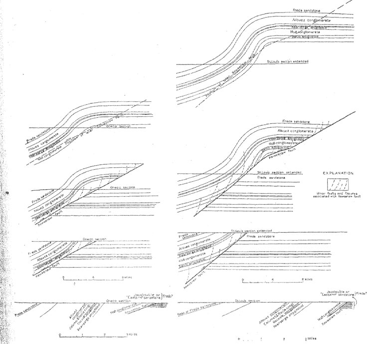
FIGURE 9. - Possible development of the Keweenaw fault and relations to beds on the assumption that the folding and faulting were both later than the deposition of the Jacobsville. sandstone
USGS Professional Paper 144 pp 46-52.
INTRUSIVE ROCKS
GENERAL FEATURES
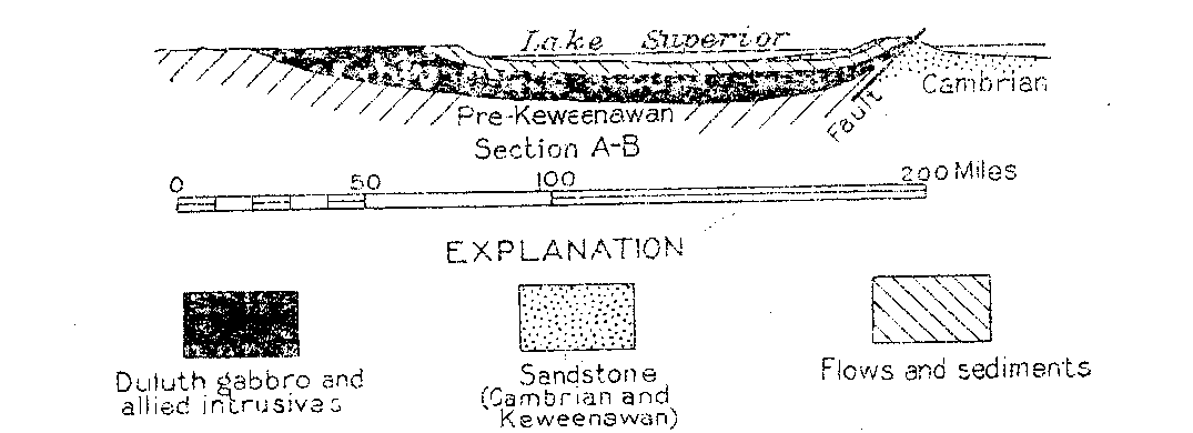
Throughout the district intrusive rocks occur in the lower part of the series, near the Keweenaw fault. (See fig. 8.) To the south, at Porcupine Mountain, and north of Lake Gogebic they are present in the middle and upper part of the series also. These intrusive rocks comprise gabbro and "gabbro aplite" similar to the gabbro and red rock of the Duluth laccolith or lopolith; quartz porphyry and felsite, which are, regarded as probably the fine-grained equivalents of the Duluth red rock; and dark chloritized basic dikes, which are present north of Lake Gogebic. These rocks have been intruded in masses of various form; a stock occurs at Mount Bohemia and probably some of the bodies near the Wisconsin boundary also are stocks; the Mount Houghton intrusive body and some bodies north of Lake Gogebic appear to be sills or laccoliths; and dikes occur at many places toward the Wisconsin boundary and very rarely in the northern portion of the district.
The similarity of the rocks to the Duluth gabbro and red rock series and their occurrence near the base of the Keweenawan and along the great Keweenaw fault has led to the belief that they are a part of the Duluth laccolith, which crops out in a similar relation on the north side of the basin and probably extends beneath the basin, as is morn fully discussed under "Structure", (p. 50).56
Rocks of the gabbro and red rock type occur at Mount Bohemia and near the Michigan - Wisconsin boundary, where relatively large bodies are surrounded by zones showing pronounced rock alteration. Diamond drilling at the Indiana mine also encountered gabbro.
The gabbro of Mount Bohemia is a dark gray-red granitoid rock of variable though typically medium grain. Its essential minerals are plagioclase, pyroxene, and magnetite in roughly equal amounts. Accessory minerals are hornblende, apatite, quartz, titanite, and sulphides. The pyroxene is partly altered to hornblende and chlorite, and the feldspar to sericite and chlorite. Leucoxene occurs as an alteration product of titaniferous magnetite. This rock has been described by Wright
57 and called oligoclase gabbro.The associated red rock or gabbro aplite is a coarser-textured rock composed essentially of oligoclase-albite and quartz with subordinate orthoclase, magnetite, apatite, titanite and zircon. It occurs as dikes arid as a stock in the gabbro and adjacent rocks.
The following analyses, taken from Lane's report,
58 show the chemical composition of these and allied intrusive rocks:Analyses of intrusive rocks from Keweenaw Point
| 1 | 2 | 3 | 4 | |
| SiO2 | 46.10 | 62.28 | 75.67 | 80.05 |
| Al2O3 | 18.95 | 17.54 | 12.43 | 9.73 |
| Fe2O3 | 5.14 | 1.55 | 2.27 | 1.72 |
| FeO | 9.83 | 5.64 | 0.15 | 0.18 |
| MgO | 6.20 | 1.51 | 0.00 | 0.00 |
| CaO | 6.71 | 3.44 | Trace | 0.83 |
| Na2O | 2.22 | 4.26 | 2.01 | 2.19 |
| H2O± | 0.41 | 1.03 | ||
| TiO2 | 2.48 | 0.98 | ||
| MnO | Trace | Trace |
1. Oligoclase gahbro, Mount Bohemia. L. Kirschbraum, analyst
2. Gabbro aplite, Mount Bohemia. L. Kirschbraum, analyst
3. Mount Houghton quartz porphyry. Michigan Geol. Survey, vol. 6, pt 2, p. 28. 1898. F. P. Burrall, analyst.
4. Mount Houghton quartz porphyry. Idem, p. 91. F. P. Burrall, analyst.
QUARTZ PORPHYRY AND FELSITE
Bodies of quartz porphyry and felsite are present at several places near the Keweenaw fault. The larger known bodies near the fault from north to south are at Fish Cove, Bare Hills, and Mount Houghton, south of Cliff, south of Ahmeek, east of Calumet, and at the Indiana mine. North of of Lake Gogebic are some large masses of quartz porphyry that are probably intrusive. At several of the localities there is no clear evidence of the relation of these masses to the flows and sediments, but where the relation is obvious they are intrusive into these rocks. The fine
felsite may show distinct flow structures in bodies that are known to be to intrusive, as is common for rocks as siliceous and fine textured as these. The "Chippewa" felsite and the felsite of Porcupine Mountain are similar to those just described but have been regarded by geologists who have, given most study to them as flows. There is also a similar rock at the Bear Lake prospect, west of Calumet, which has the appearance of a rhyolite flow but may be intrusive. This is in the Freda sandstone and is stratigraphically the highest known occurrence of felsite.The rocks vary considerably in texture in different bodies and also in a single body. In the coarser varieties phenocrysts of quartz and feldspar 2 or 3 millimeters in diameter are present rather abundantly. These are inclosed in a felsitic groundmass of quartz and feldspar. The finer varieties are typical felsites, in which phenocrysts are either small and scarce or altogether absent. Dark minerals are characteristically absent from these rocks, but practically all have
a reddish color due to the presence of countless dustlike particles of hematite, which appears to be an original constituent. All these rocks, as well as the pebbles of similar felsites and quartz porphyries in the conglomerates, are rich in ferric iron. The chemical composition of the Mount Houghton mass is shown in the analyses given above. The other bodies are apparently of similar composition.BASIC DIKES
Very few basic dikes have been noted in the part of the district that has been most studied. A few examples of probable dikes were seen in the drill cores from the north end of the district. In the Onondaga drill-section, north of Lake Gogebic, numerous small fine-grained green, highly chloritized dikes cut both the quartz porphyry and the lava flows. The intruded racks for a few inches from the dike contact are considerably chloritized.
AGE OF INTRUSIVE ROCKS
There is no basis far determining the age of the intrusive rocks more definitely than as Keweenawan or post-Keweenawan. The felsite fragments in the conglomerates closely resemble those found in plats and are generally believed to have bean, derived from similar masses; as they are unlike any earlier rocks known the the region. If this belief is correct, felsitic intrusion, extrusion, or both must have begun early in Keweenawan time to have formed the source of the early conglomerates, and the igneous activity probably continued into late Keweenawan time, at least in the Porcupine Mountain area, where the latest known Keweenawan rocks are involved in the domical structure that is attributed to intrusion. Similar evidence of late igneous activity is afforded by the presence of a fine-grained acidic rock well up in the the Freda sandstone (upper Keweenawan) near Bear Lake. Whether the intrusive rocks near the base of
the series, as represented along Keweenaw Point, are early or late is not known.STRUCTURE
The broader structural features of the Lake Superior region have been Summarized by Van Hise and Leith,
59 and only such features need be set forth here as bear directly on the rocks of the copper district.FOLDS
The dominating structural feature of the region is the Lake Superior syncline. This structural basin is roughly outlined by the present area of Lake Superior with a southwestern extension into Minnesota. West of Keweenaw Point the general strike of the axis of the basin is about N. 30° E., extending into Minnesota. East of Keweenaw Point the strike is east of south. In this direction the syncline extends to the east end of Lake Superior. 'Keweenaw Point is on the south limb of this syncline. The north limb is exposed on the north shore of Lake Superior and on Isle Royal. Beds that are thought to be at essentially the same horizons crop out on Keweenaw Point and on Isle Royal, about 50 miles apart across the general strike of the basin.
The syncline is asymmetrical, the beds on the south limb dipping notably more steeply. than those on the north. There is a steady flattening in the dip of the beds from the base of the Keweenawan series toward the top. On Keweenaw Point the dip ranges from 80° in the lower beds to 10° at some points where the upper Keweenawan sandstones dip under the lake.
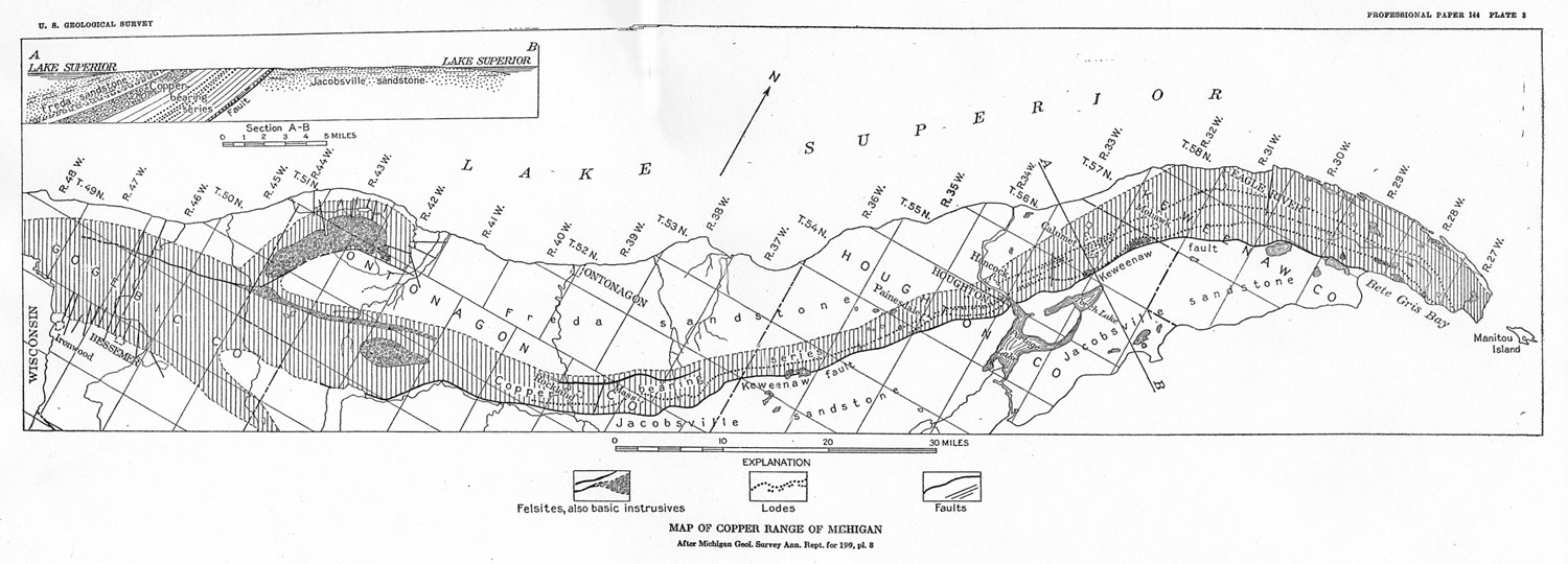
The south limb of the Lake Superior syncline is irregular in detail, being made up of a series of transverse anticlines and synclines that pitch. down the dip of the main trough. (See pl. 3.) Keweenaw Point is near the crest of a northward-pitching anticline that causes the strike of the beds to change between the south and north ends from north of east, through east, to south of east. To the southwest the Keweenaw anticline merges into the Ontonagon syncline. West of the Ontonagon syncline is another anticline with its crest about at Bessemer and Ironwood. These are very broad, open folds, the distance between the adjacent crests of the Bessemer and Keweenaw anticlines being approximately 110 miles. On these large cross folds are numerous subordinate anticlines and synclines of similar character and trend as the Allouez anticline, the Isle Royale (mine) syncline, the Baltic anticline, the Winona anticline, the Firesteel River syncline, and the Mass anticline. These also are broad, open folds but are only 5 to 10 miles across, as contrasted with 100 miles for the major cross folds. Some of the folds, such as the Allouez anticline and the Isle Royale syncline, show a rather uniform bending of the beds, with some faulting near the crest. In others, such as the Baltic and Mass anticlines, the beds are bent sharply at the crests and at the margins of the folds, but the limbs of the folds are fairly straight.
The domical uplift at Porcupine Mountain, also a minor fold on the, south limb of the Lake Superior syncline, is 12 to 15 miles long and 4 to 6 miles wide. It has the same general trend as the Lake Superior syncline. Numerous faults are associated with this dome.
FAULTS
The Keweenaw fault, the major fault of the region, strikes in a general northeasterly direction, parallel with the Lake Superior syncline in this area. It varies in strike, however, and in general bends with the transverse northward-pitching anticlines and synclines on the south limb of the Lake Superior Basin. The fault is known from Bete Gris Bay, near the end of Keweenaw Point, where it is covered by the waters of Lake Superior, to Lake Gogebic, a distance of about 100 miles. It doubtless extends farther east under Lake Superior and may be represented to the west by faults that have been found in Wisconsin.
60 The fault is reverse or overthrust and has forced the Keweenawan rocks up and over the Jacobsville ("Eastern" or Cambrian) sandstone and thus duplicated the Keweenawan and the overlying sandstone. The rocks of the main Copper Range and the South Trap Range are believed to have been once continuous and are now separated by the Keweenaw fault. The fault dips northwest. The angle of dip is known in ,few places but where known ranges from 20° to 70° and in the main steepens or flattens with the dip of the overlying lavas. The rocks adjacent to the fault are much broken and displaced. In general the normal northward-dipping lava flows on the hanging-wall side of the fault are bent downward so that in places the dip is reversed, and the flat-lying sandstones on the footwall side are turned up rather abruptly. Associated with the main fault are numerous branch faults, some of which are known to diverge half a mile from the main fault, as that at the Mayflower-Old Colony mine. The flows in the block between the main fault and the branch are nearly flat-lying or have a southerly dip.The rocks of the lava flows for several hundred feet from the fault are in most places greatly broken and brecciated. This condition has rendered diamond drilling near the fault difficult and expensive and is the main reason why so little definite information regarding the attitude of the fault is available. The sandstone is less brecciated.. In the following paragraphs are recorded the definite facts concerning the fault that are available:
At Bete Gris the fault can be seen under the shallow waters of the bay, but little is known of its attitude. Southeast of Cliff a diamond-drill section shows two faults over half a mile apart, with a block of nearly horizontal flows between them.
At the Mayflower-Old Colony mine diamond drilling has shown a branch diverging from the main fault to a maximum distance of about, half a mile. Between the main fault and the branch the beds are nearly horizontal or have a slight southerly dip opposite to the normal dip, The branch fault was evidently formed after there had been some movement on the main fault, as it reaches the "Eastern" sandstone in depth. The dip of the branch fault is somewhat steeper than the normal dip of the trap beds at this locality. The dip of the main fault is not known but is evidently less.
At Wall Ravine the fault is poorly exposed but seems to dip about 20°, The "Eastern" sandstone beneath and adjacent to the fault is sharply upturned, and a vertical "wall" formed by a resistant layer of the upturned "Eastern" sandstone has given the name to the ravine.
The St. Louis diamond-drill sections show the fault to dip almost parallel with the normal dip of the trap beds, about 38°, and there seems to be little disturbance of the rocks near the fault.
Where exposed at Douglass Houghton Falls the fault dips 30°-32°, a flatter angle than the normal dip of the beds. The beds near the fault, however, dip only 15°-20°.
In the Torch Lake diamond-drill section the relations are complicated by intrusion, so that the dip of the fault is uncertain. The beds, however, flatten very much as they approach the fault.
Where exposed at Hungarian Falls the fault dips 30°-32°. The beds above the fault are relatively flat and are evidently dragged down by the fault.
At Oneco two diamond-drill holes cut the fault-at depth, and its outcrop has been located fairly closely near by. The average dip of the fault is 17° between the outcrop and the nearer hole and 22° between the outcrop and the more distant hole. The beds flatten in dip toward the fault and are possibly overturned near it.
According to H. W. Fesing the trap beds exposed by the explorations near the fault along the supposed Baltic horizon in the lands of the Arcadian Consolidated Copper Co. are completely overturned and dip to the east.
Where exposed in a ravine south of Isle Royal the fault dips 56°, nearly parallel to the beds above it. There are other faults, probably related to the Keweenaw fault, within the trap series near by.
At the Atlantic prospect the fault was located at points 1,200 feet apart vertically and 300 feet horizontally; the dip, as indicated by these points, is 50°, which is somewhat flatter than the dip of the trap beds immediately above.
In the vicinity of the Indiana mine the beds near the fault are much broken and contain intrusive rocks.
At the Lake and South Lake mines there is a broad, gentle syncline and a narrow, steep anticline between the fault and the point where the rocks have the normal westerly dip. The folding that produced these features was a part of the fault movement,
The fault has been exposed at the Victoria mine, where a section of the adit shows that it dips about 70°, a little more steeply than the beds.
In addition to the Keweenaw fault and those closely associated with it already mentioned, there are many fissures near the Keweenaw fault that dip nearly parallel with or somewhat steeper than the beds. These are particularly conspicuous in the mines opened near the Keweenaw fault. On these strike fissures the movement may be scarcely noticeable or may be a few feet but is rarely large.
There are also a few reverse faults which cut the beds transversely at a somewhat higher angle, such as the Hancock and Isle Royale faults, with apparent horizontal displacements of about 600 and 175 feet, respectively, but in which the actual displacement along the direction of movement was doubtless several times as much. The Branch fissure of the Michigan (Minesota mine) may be of this class but has a relatively small displacement.
Another group that may be put in this class are faults or slips that parallel the beds. These are difficult to recognize, and it is usually impossible to determine the amount of movement on them, but there can be no doubt that faulting has occurred between the beds, especially on the conglomerate beds, which rather characteristically have on the hanging-wall side a heavy gouge that has resulted from movement. Evidently the plane surface of the conglomerates as contrasted with the rough surface of most of the flows made the top of the conglomerates a zone of easy slipping, and much of the movement during the tilting of the beds appears to have occurred on the conglomerates. L. L. Hubbard61 has particularly emphasized faulting of this type.
There are large reverse faults around the Porcupine Mountain dome, Wright and Lane62 show a fault extending along the entire south margin of the dome, and there is a strong reverse fault in the workings of the White Pine mine.
Near the crests of the anticlines there are numerous transverse fissures that apparently have resulted from the bending of the rocks when the anticlines were formed. These are particularly noticeable on the Keweenaw anticline, from the North American mine to Copper Harbor, where the fissures cut the Greenstone ridge. In the straight stretch between the Allouez anticline and the beginning of the sharp curving of the Keweenaw anticline at the North American mine. The Greenstone flow is massive and almost free from fissures; but it is strongly fissured around the anticline. Many of the fissures are mineralized - the Cliff, Phoenix, Copper Falls, Central, Delaware, and many others. Most of the low gaps through the Greenstone flow, have also evidently been determined by fissures. Along many of the tension breaks there has been some movement, and along some it may reach tens and possibly hundreds of feet, though there are no great faults. Fissures and faults of the same character are present on some of the smaller folds as the Allouez, Baltic, and Mass anticlines.
Where there is much displacement of the faults associated with the anticlines, it is commonly in a wide zone of shattering; in some extending over a hundred or even several hundred feet, as in the Allouez shatter zone, on the Allouez anticline, and the zone between the Baltic and Trimountain mines, on the Baltic anticline. Commonly where there has been much movement one or more planes in the zone show strong gouges.
The fissures and faults on the smaller anticlines are mineralized - for example, the Mass fissure and Arsenide fissure, on the Allouez anticline, and similar though less highly mineralized cross fissures on the Baltic and other anticlines.
AGE AND CAUSE OF FOLDING AND FAULTING
There is a very close relation between folding, faulting, and igneous activity in the region, and all three processes are probably different expressions resulting from a common cause,
Two general ideas have been advanced regarding the relations of folding to igneous activity. One assumes that the synclinal structure of the Lake Superior basin is the result of some phase of igneous activity. Thus Lane63 has thought that the material of the lavas came from beneath the Lake Superior basin and that the space thus vacated was filled by the settling or slumping of the crust above. Grout64 considers the subsidence of the roof of the Duluth gabbro laccolith or lopolith a factor in the formation of the Lake Superior syncline, Hotchkiss65 likewise considers the origin of the syncline to be associated with the igneous activity. He pictures a great body of igneous material rising slowly through the earth's crust beneath the present Lake Superior basin, For a long period before Keweenawan time this rising igneous mass elevated the surface above it and tilted the rock away from the present basin. The rising surface was eroded, and the material thus derived was deposited around the margin. In Keweenawan time the magma broke through to the surface as basaltic and felsitic flows. This release of pressure and transfer of material to the surface caused the crust to settle. The process of transfer and settling continued through the Keweenawan epoch, resulting in a tilting of the beds toward the axis of the basin, the earlier beds being most affected and the later ones progressively less, as outlined below.
According to the second conception, orogenic movement; one phase of which was the folding of the Lake Superior syncline, is regarded as the cause rather than the effect of the igneous activity. Van Rise and Leith,66 though not denying the possible dependence of the folding upon the extrusion of the Keweenawan basalt, believe it reasonable to assume that the dominant trend of the folds of the pre-Cambrian shield was probably established before Keweenawan time and that a thrust from the south against a continental area to the north was effective in the folding of the Lake Superior syncline.
Whichever cause was effective or predominant, the folding took place during Keweenawan time. However, it took place slowly. If Lane's correlation of flows and sediments from one side of the lake to the other is correct, erosion and deposition must have kept pace with the formation of the syncline, so that there was no considerable physiographic basin at any period, and if the material moved from the center of the basin outward, the center must have been a physiographic elevation. In both explanations the folding is presumed to have been in progress during Keweenawan time and to have been essentially completed at its end, so that late Keweenawan beds were little affected,
The domical character of the Porcupine Mountain uplift and the known presence of intrusive rocks within it strongly suggest that this fold has resulted from the intrusion of igneous material, possibly in laccolithic form. There are also outcrops of intrusive bodies near the crests of the Keweenaw anticline and the Bessemer-Ironwood anticline, and an intrusive body underlies the Allouez anticline. Some small intrusive bodies, however, such as that east of Calumet and that at the Indiana mine, are not associated with notable anticlines. On the whole there seems to be some suggestion that the transverse folds are associated with intrusive bodies, but it is not clear whether the intrusion was the cause or the effect of the folding. The transverse folds involve rocks of late Keweenawan age and were evidently formed during or after Keweenawan time.
The cause and time of formation of the Keweenaw fault are not susceptible of rigid proof with the evidence now available, as is indicated by the differences of opinion concerning it. Van Hise and Leith regard the faulting as post-Cambrian, possibly post-Cretaceous. Lane believes that it started in Keweenawan time and continued "ages later."
It is of course clear that there has been movement since the deposition of the Jacobsville ("Eastern") sandstone, The reverse or overthrust character of the fault and the attitude of the adjacent rocks indicate that this, like many such faults, started as a fold, which broke when the elastic limit of the rocks was exceeded. The fault closely parallels the Lake Superior syncline, and the block to the north, toward the center of the syncline, was thrust upward and outward relative to the block to the south. If it is assumed that the entire Keweenawan series was laid down before the formation of the Lake Superior basin was begun, the displacement on the fault necessary to bring the Cambrian Jacobsville sandstone into contact with middle Keweenawan beds would be about 3 miles, and the relations as they exist might have been produced by combined folding and faulting, as shown in the accompanying diagram. (See fig 9.) If, as seems likely, the Lake Superior basin was in process of formation during Keweenawan time and the fold that preceded the fault was also being formed then, the Jacobsville sandstone was laid down unconformably on the upturned edges of the earlier Keweenawan beds and a movement on the fault of only a few thousand feet would account for the known displacement of the Jacobsviile sandstone and produce the attitude, of the beds adjacent to the fault, as they are known and as is shown in Figure 10.
Under this second assumption the movement on the fold and subsequent fault began in Keweenawan time and continued after the Jacobsville ( "Eastern") sandstone was laid down, possibly for a long time after.
FIGURE 9. - Possible development of the Keweenaw fault and relations to beds on
the assumption that the folding and faulting were both later than the
deposition of the Jacobsville. sandstone
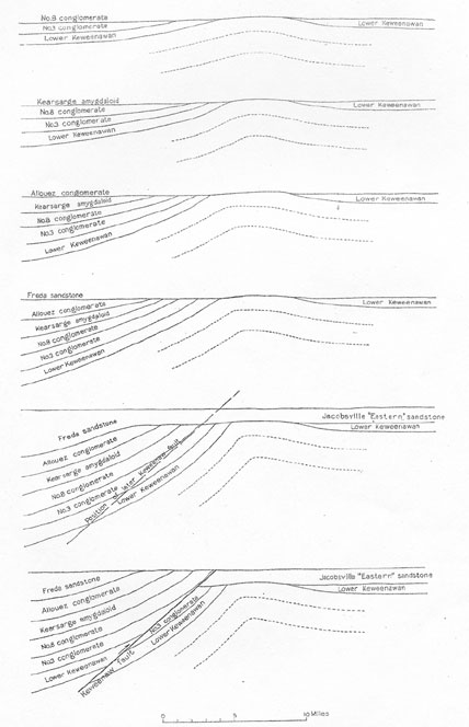
FIGURE 10. - Possible development of the Keweenaw fault on
the assumption that the folding was earlier than the
deposition of the Jacobsville sandstone.
NOTES
56 Van Rise, C, R., and Leith, C. K. op. cit., pp 377-378. Grout, F. F., The lopolith, an igneous form exemplified by the Duluth gabbro: Am. Jour. Sci., 4th ser., vol. 36, pp, 516-522, 1918.
57 Wright, F. E., The intrusive rocks of Mount Bohemia, Mich.: Michigan Geol. Survey Rept. for 1908, pp. 363-370, 1909.
58 Lane, A. C., Michigan Geol Survey Pub. 6 (Geol ser.4), vol. 1, pp. 106-109, 1911.
59 Van Hise, C. R., and Leith, C. K., U. S. Geol. Survey Mon. 52, P. 620, 1911.
60 Ardrich, H. R.., op. cit., p, 569.
61 Michigan Geol. Survey, vol. 6, p. 91, 1898.
62 Wright, F. E., and Lane, A. C.., Michigan Geol. Survey Rept. for 1908, pi. 1, 1909.
63 Lane, A. C., Michigan Geol. Survey Pub. 6 (Geol, ser. 4), vol. 1, p. 22, 1911
64 Grout, F. F., The lopolith-an igneous form exemplified by the Duluth gabbro: Am. Jour. Sci., 4th ser., vol. 46, pp, 516-522, 1918.
65 Hotchkiss, W. O., The Lake Superior geosyncline: Geol. Soc. America Bull., vol. 34, pp. 667-673, 1923.
66 Hise, C. R., and Leith, C. R., op. cit., pp. 411, 622, 623.
Collector's Corner Previous section Table of Contents Next section