USGS Professional Paper 144 pp 14-17
GEOGRAPHY
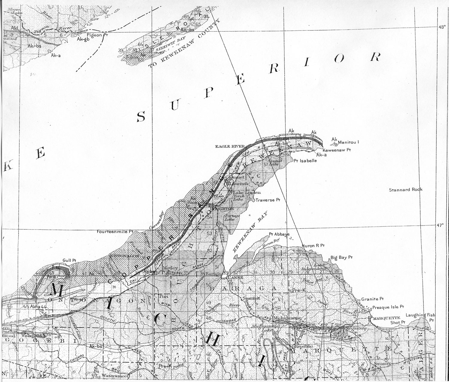
Location. - The copper district of Michigan is in the extreme northern part of the northern peninsula, in Keweenaw, Houghton, and Ontonagon Counties. Its mines all lie within a narrow belt from 2 to 4 miles wide and more than 100 miles long.
Topography. - The most prominent topographic feature of the copper country is a broad flat-topped ridge or narrow plateau extending in a northeasterly direction through the district and falling off to a lowland both to the north and to the south. The northern portion projects into Lake Superior as Keweenaw Point. This plateau rises to a general level of 500 to 600 feet above Lake Superior, with ridges such as the Greenstone and Bohemia Ranges, in Keweenaw County, rising still higher. In the south end of the district the Porcupine Mountains form a prominent feature north of the main ridge.
The main ridge or plateau is cut through by several low transverse gaps or valleys. The deepest are the Portage Lake and Ontonagon River valleys, but there are many others of similar type.
The drainage is mainly outward from the central ridge, and most of the streams are small. The largest is Ontonagon River, which rises south of the main ridge and flows northward through the Ontonagon Gap. As most of the streams have small basins, they are subject to marked variations in flow. In dry summers and continuously cold winters the flow in many of the streams is very small, but while the snow is rapidly melting in the spring there is a large flow.
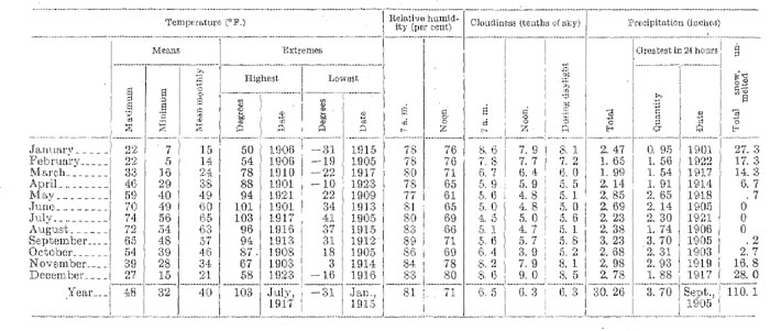
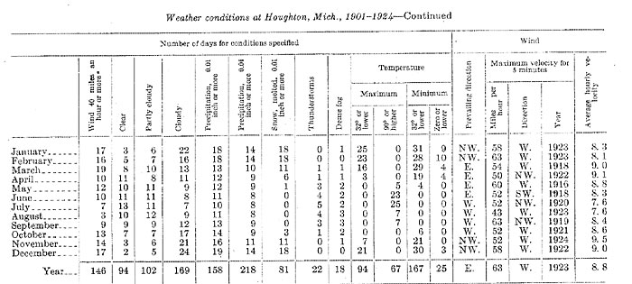
Climate. - The following statements of the climatic conditions are taken from the summary for 1924 prepared by Howard B. Cowdrick, meteorologist of the Houghton station of the Weather Bureau, United States Department of Agriculture. The Houghton station. is in the Portage Lake valley, 82 feet above lake level, and the average conditions on the Copper Range Plateau both north and south of it are some what more severe. The waters of Lake Superior on three sides of the region greatly temper the climate. Killing frost in the autumn is later than at many stations much farther south, and although the spring opens late, there are almost never periods of high temperature followed by injurious freezing weather. For the last 23 years the average date of the last killing frost in spring has fallen in May and that of the first in autumn has fallen in October, and the average interval between them has been 149 days. The summer climate, with its long sunny days and cool nights, is almost perfect. The winters are cold but not unpleasant. A great amount of snow falls, but it is usually dry, and because of expertness developed through many years of experience in handling it, the railroads and electric lines are not seriously inconvenienced. Sleet is almost unknown.
Weather conditions at Houghton, Mich. 1901-1924
 a Total for period.
Industries. - The chief industry of Keweenaw Point is copper mining and smelting; of far less importance are lumbering and agriculture. In addition to these there is some fishing and a little manufacturing.
Copper mining has been the most important industry for many years, and until the end of the World War, when copper mining nearly everywhere was curtailed, it had made a pretty steady growth.
Lumbering is of course decreasing in importance as the original timber is removed, but there is still much original hardwood timber standing, and lumbering will continue for some time. As the timber has been cut some of the land has been cleared for farming, and agriculture has been steadily expanding. Much of the soil is good, and although the seasons are short, especially on the higher lands of the Copper Range, the region is suited to certain types of agriculture, especially the growing of potatoes and root crops generally. Dairy products are also more than sufficient to supply local demands.
Transportation. - The district borders on Lake Superior, and Portage and Torch Lakes and the Portage Lake Canal bring lake transportation into its heart. Most of the heavy freight, such as fuel and much of the copper, therefore has the advantage of lake freight rates. Lake transportation usually opens by May 1 and closes in December.
The district is also connected with outside points by the Chicago, Milwaukee & St. Paul Railway and the Duluth, South Shore & Atlantic Railroad. It is also served by the Mineral Range Railroad and the Copper Range Railroad. The Keweenaw Central Railroad has served the northern part of the district in the past and would undoubtedly resume operation if conditions should justify. Several of the mines are connected with the mills and smelters by privately owned railroads.
An improved highway extends from Copper Harbor, near the end of Keweenaw Point, to Rockland, on Ontonagon River. This road, together with numerous branches, brings practically all parts of the district within a few miles of good highways, which are open to automobile traffic for about eight months of the year.
The north end of the Porcupine Mountain section also has improved highways, and the Chicago, Milwaukee & St. Paul Railway has a branch to the White Pine mine.
Power. - Practically all power for the district is generated from coal brought in by Lake steamers. Much of the power is used directly as steam power or as compressed air produced by steam power, but there is a steadily increasing use of electric power generated at central plants.
The only water-power plant in the district is that of the Victoria Copper Co. on the West Branch of Ontonagon River. A fall of 71 feet was utilized to produce compressed air directly, which operated all the machinery of the mine and mill. A dam to store water in Lake Gogebic helps to equalize the flow of the river, and the power available could be considerably increased by raising the dam. There is a fall on the East Branch of Ontonagon River that has not yet been utilized for developing power, and some power could also be generated on other small streams in the district. The irregular seasonal flow of the streams, however, would make storage dams necessary to develop power continuously.
PHYSIOGRAPHY
An account of the development of the physiographic features of the copper district requires consideration of a much wider area than the district itself. Such descriptions have been prepared by Martin7 for the Lake Superior region, by Leverett8 for the northern peninsula, and by Lane9 for the copper district, and only a brief outline will be presented here.
The ridge or plateau known as the Copper Range represents an old mature erosion surface with monadnocks rising above its general level and also valleys below that level. With the elevation of this old surface the softer rocks on each side of the present range were eroded to form the present lowlands, while the crystalline rocks were but little affected. (See pl. 53.) This was the condition of the region before the glacial epoch.
The glaciation had little to do in forming the major physiography features, but it affected the minor features profoundly. When the ice swept over the region it scoured off the soil and the weathered outcrops of the rocks. It smoothed the outlines and probably widened and deepened the valleys somewhat, but it did not change the major rock features. In local protected areas the effect of preglacial weathering is preserved - for example, it can be well seen in a shaft on the Petherick vein, near Copper Falls, Keweenaw County.
The deposits laid down by the ice and the accompanying streams are prominent features of the detail of the physiography and are economically important both from the viewpoint of the farmer, because they form the soil, and from that of the miner, because they constitute a rock cover which affects the ease of both exploration and development. There are four principal types of glacial deposits on the Copper Range - the general till sheet or ground moraine; moraines formed around the margins of the ice tongues; deposits formed in glacial lakes; and deposits laid down by streams flowing from the ice.
The most extensive of these deposits is the ground moraine, which was left in greater or less amount everywhere as the ice melted. It covers practically all the range except a few steep ridges from which it has been removed or on which it could not accumulate.
Over much of the area it forms a rather shallow mantle, which is not continuous but fills minor depressions and covers the outcrops of the weaker rocks such as the amygdaloids.
The marginal moraines cover a much smaller area. The most prominent one, which outlines the ice lobe that moved down Keweenaw Bay, touches the Copper Range at Wheal Kate Mountain, near South Range, and follows it southwestward to a point beyond Winona, where it turns southward around Keweenaw Bay. This moraine buries the rocks deeply and is a serious impediment to prospecting.
The lake deposits were formed in the lakes along the south margin of the ice. In their early stages these lakes drained into the basin of Mississippi River. Later, as the ice melted, lower outlets were opened to the east, and the lakes dropped to successively lower levels. The most extensive of these lakes in the Copper Range was Lake Duluth, which covered most of the area. At Calumet its highest shore line surrounds Centennial Heights, about 700 feet above the level of Lake Superior, and in the south end of the district only the higher summits projected as islands. This highest stage was followed by successively lower stages whose positions are marked by old beach lines. Since these were formed the land has been tilted so that there is a slight rise in altitude of each beach line from south to north, the amount of which has not been determined for the Copper Range.
In these lakes were formed extensive deposits of clay mixed with boulders, especially in the southern part of the range. These deposits have not buried the rocks as deeply as the marginal moraine, but in places they constitute a decided handicap to prospecting.
Since the glacial epoch erosion has modified the deposits somewhat, especially near streams, but in the main there has been little change. (See pl. 54.)
BEDROCK GEOLOGY BROADER RELATIONS
Location and extent. - The native copper deposits of Lake Superior are inclosed in rocks of Keweenawan age. The area in which these rocks are exposed lies in the southern part of the pre-Cambrian shield of North America and forms a part of the Lake Superior basin. Along the south shore of the lake it extends from Keweenaw Point southwestward through northern Wisconsin into Minnesota. (See pl. 2.) The Keweenawan rocks border the north shore of the lake in Minnesota to the Canadian boundary, crop out on Isle Royal, and in Canada appear in the Black Bay and Thunder Bay districts and extend northward around Lake Nipigon. To the east of this almost continuous area they occur in scattered outcrops along the shore and on islands of Lake Superior.
Character of the rocks. - The Keweenawan series comprises coarse clastic sediments and intrusive and extrusive igneous rocks. Both the base and the upper part of the series were formed during periods of sedimentation. The igneous activity became dominant after a maximum of 1,500 feet of sediments had been deposited, when basaltic flows were poured out, one after another, with occasional short intervening periods of sedimentation. More rarely acidic eruptions occurred. The flows were probably fissure eruptions, how many there were is not known, but they are to be numbered in the hundreds. Igneous activity gradually ceased, the intervening periods of sedimentation becoming more frequent and longer. The upper part of the series is made up largely of a thick conglomerate overlain by a thick sandstone.
Intrusion probably though not certainly occurred during the Keweenawan epoch. On the north shore the great Duluth gabbro laccolith of Minnesota was intruded essentially along the unconformity at the base of the Keweenawan. Similar intrusive rocks occur south of the lake in Wisconsin, and it is thought that these are outcrops of the same great body extending beneath the lake, from one side of the Lake Superior synclinal basin to the other. Smaller intrusive bodies occur toward the base of the Keweena wan at intervals along Keweenaw Point. Both their petrographic character and their position in the series suggest that they are contemporaneous with and derived from the same magma as the Duluth gabbro. Other examples of intrusive rocks that are probably of Keweenawan age are the dikes in the Gogebic iron country and the Logan sills in Minnesota and Ontario.
NOTES
7 Martin, Lawrence, U. S. Geol. Survey Mon. 52, p. 85, 1911.
8 Leverett, Frank, Michigan Geol. Survey Pub. 7, Geol. ser. 5, 1911.
9 Lane, A. C., Michigan Geol. Survey Pub. 6, Geol. ser. 4, p. 48, 1911.
Collector's Corner Previous section Table of Contents Next section