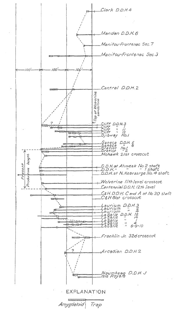
FIGURE 1. - Variation in thickness of Kearsarge flow
USGS Professional Paper 144 pp 17-25
STRATIGRAPHY
MAPS AND SECTIONS
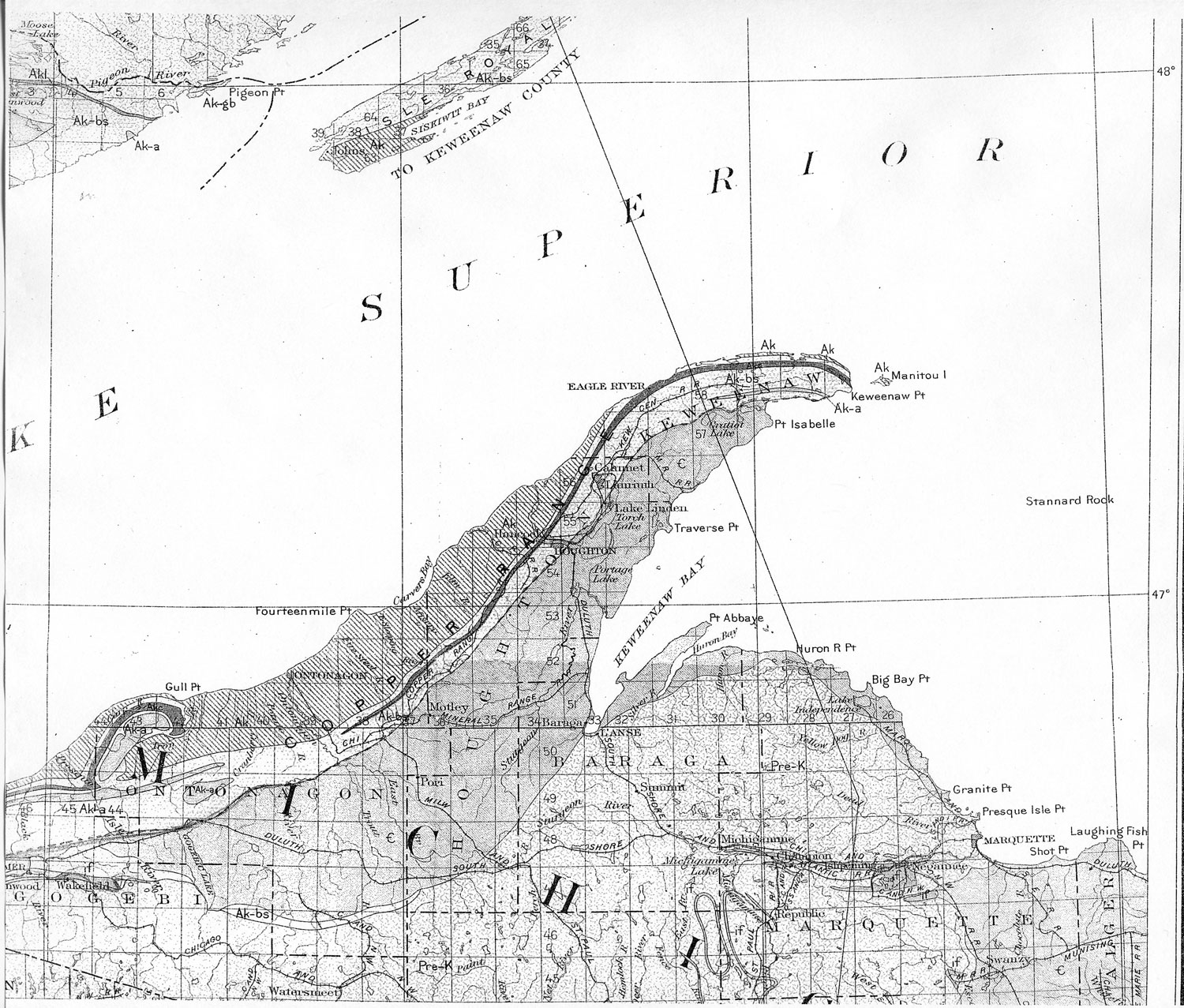
The detailed geologic maps and sections (pls. 2-32) are based largely on data from diamond drilling and underground openings. Outcrops have of course been used as far as possible. As the region is largely covered with drift and the depth to bedrock is unknown except at the location of drill holes or other openings, it was decided to show the rock beds on the surface map as projected on their dip through the drift to the surface. Where there is no drift cover the outcrop as shown coincides with the actual bedrock outcrop. Where there is a drift covering a given contact in westward-dipping beds is shown farther east than its position on the bedrock surface by a distance that varies with the thickness of the drift and the dip of the beds. The dip is indicated on the map and shown on the sections, and the thickness of drift at the drill holes is shown on the sections, and it is also indicated on the map by a gap between the location of the hole and the position of the bedrock.
Near the Keweenaw fault, where the beds are in general considerably broken and in many places have low dips, the surface outcrop has not been shown. The structure so far as it is known is indicated in the sections.
On both maps and sections the character of the traps is shown by letters, as O for ophites, M for melaphyres. The character of amygdaloids, as fragmental, scoriaceous, or cellular, is shown by symbols.
AGE AND RELATIONS
The rocks of Keweenaw Point are of Keweenawan and Cambrian age. On the Gogebic Iron Range; near by, the Keweenaw an rests unconformably upon the upper Huronian, arid Keweenawan dikes cut the earlier rocks. Overlying the upper Keweenawan, without apparent unconformity or abrupt change of character, is a sandstone which has been considered to be Upper Cambrian. This relation does not exist on Keweenaw Point, where the upper Keweenawan sandstone (called the Freda) is separated from the Upper Cambrian sandstone (the Jacobsville, "Eastern," or Lake Superior sandstone) by a great overthrust fault. In the valley of St. Croix River, in western Wisconsin, fossiliferous Upper Cambrian sandstone lies unconformably on middle Keweenawan beds. The Jacobsville sandstone may be likewise unconformable on the Keweenawan in the South Trap Range of Michigan, but there the relations are obscured by faulting, and the problem is complicated further by the doubt that exists regarding the equivalence of the Jacobsville ("Eastern") sandstone to the Upper Cambrian of the St. Croix Valley. This relation may mean simply that the Lake Superior basin was forming during Keweenawan time and in places the latest member was laid down unconformablv on the earlier members, which had been already tilted, though there was no break in the general series.
In northern Wisconsin the Freda sandstone is overlain conformably by other sandstones of Keweenawan age, into which, indeed, it seems to grade imperceptibly. It would appear from this relation that the formations were laid down in one period of continuous deposition without interruption by diastrophic movements. Although the accepted usage of the United States Geological Survey is to group the Keweenawan with the pre-Cambrian, the fact that the apparently major unconformity lies below the Keweenawan series rather than above it has led some geologists to the view that the major division between the Cambrian and pre-Cambrian should be placed at the base of the Keweenawan. Thus, Lane groups the rocks of the Keweenawan as Cambrian.
10 The present work has contributed nothing of significance toward determining the relations, and it seems to be still an open question with good arguments on both sides.10aGENERAL CHARACTER AND DISTRIBUTION
The Keweenawan series is divided in a general way into upper, middle, and lower Keweenawan, which are further subdivided into groups and formations.
11 The several workers in the district have classed the subdivisions somewhat differently, as indicated in the following table:Classification of subdivisions of the Keweenawan series.
| Name | Thickness (feet) | Classification | ||
| Irving | Van Hise and Leith | Lane and Gordon | ||
| Freda sandstone | 900-(?) | Upper Keweenawan | Upper Keweenawan | Upper Keweenawan |
| Nonesuch shale | 350-600 | Lower Keweenawan | ||
| Outer Conglomerate | 1,000-3,500 | |||
| Lake Shore trap | 400-1,800 | Lower Keweenawan | Middle Keweenawan | |
| Great conglomerate | 340-2,200 | |||
| Eagle River group | 1,417-2,300 | |||
| Ashbed group | 1,456-2,400 | |||
| Central Mine group | 3,823-25,000 | |||
| Bohemia Range group | (?)-9,500 | |||
| Lower Keweenawan | ||||
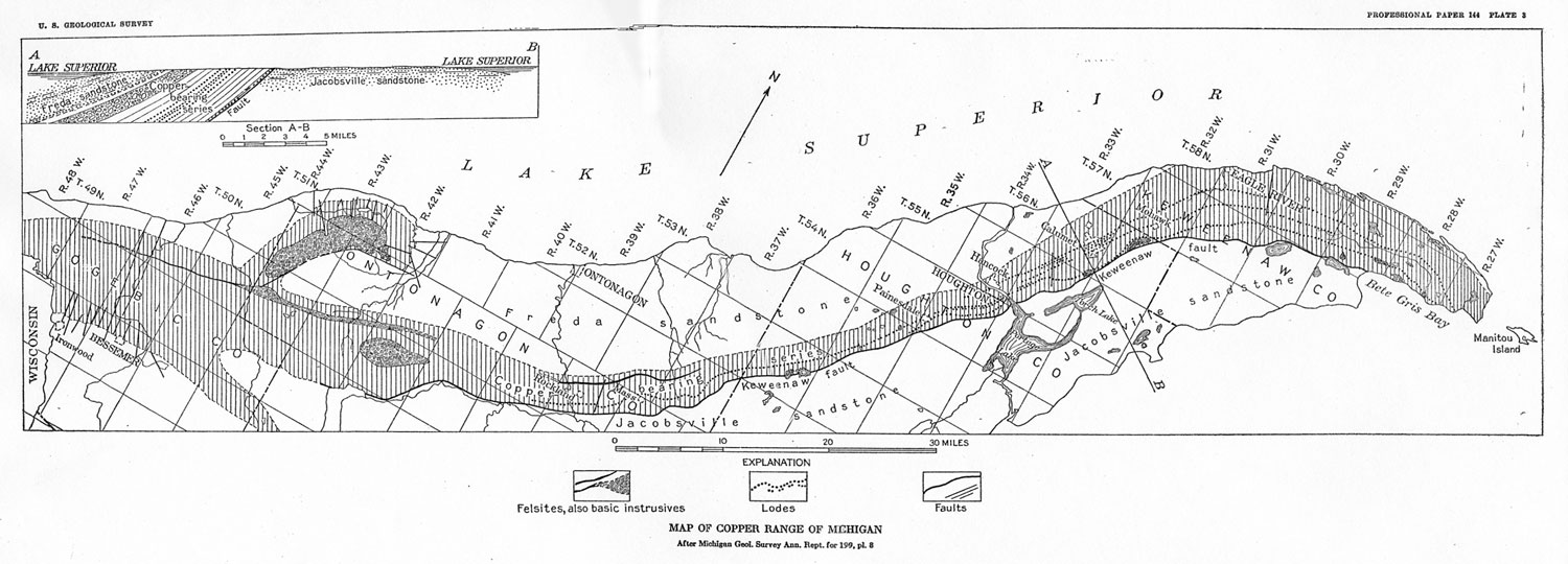
The rocks consist of acidic and basic intrusive and extrusive rocks, shale, sandstone, conglomerate, ash, and tuff. The same rock types, both igneous and sedimentary, the characteristic of the Keweenawan of the entire Lake Superior region. The Keweenaw Point belt extends south-westward into northern Wisconsin and dips northwestward under Lake Superior. Rocks of the same types emerge on the north side of the Lake Superior syncline in Minnesota, Isle Royal, and Ontario. Lane believes that some of the specific horizons identified in the Michigan copper district can be recognized on Isle Royal.
12SEDIMENTS
DISTRIBUTION
The sediments are decidedly subordinate in the lower groups on Keweenaw Point. They become increasingly abundant in the upper groups, however, constituting practically the entire thickness of the series above the Eagle River group.
GENERAL CHARACTER
The sediments are predominantly red in color, feldspathic, and poorly sorted; they show horseshoe-shaped ripple marks, cross-bedding, and mud cracks, and so far as known they have no fossils. Their characteristics indicate that they were deposited largely or entirely under terrestrial conditions.
13CONGLOMERATE
Under conglomerate, as here considered, are included rocks of two types - Those that are composed predominantly of felsitic material and those that are composed of fragments of amygdaloid in a basic sand and have heretofore been called either amygdaloid conglomerate, or scoriaceous amygdaloid. A bed of the second type immediately underlies or forms the lower part of the felsitic Calumet & Hecla conglomerate but is distinct from it in character and is far more extensive. The two types are distinct in composition and in source of material, and it seems desirable for certain purposes to regard them as separate units, though from purely stratigraphic considerations they might well be grouped together, as they commonly have been.
FELSITE CONGLOMERATE
Extent and thickness of beds. - Conglomerate of the felsitic type is the principal sedimentary rock in the copper district. Beds of it. range in thickness from a few inches to 3,500 feet. Some have been traced for many miles along the strike; the Allouez conglomerate, for instance, is recognized for over 50 miles along the strike and has been identified by Lane across the lake on Isle Royal, though nowhere is it known to be more than 50 feet in thickness. The recognition and enumeration by Marvine
14 of 22 conglomerates numbered from the base of the series upward to the Great conglomerate constitutes the chief basis of correlation used in all the later geologic work in the district.Vertical distribution. - The conglomerates form a relatively small proportion of the lower part of the series and a large proportion of the upper part. In the lower part many of the flows have no felsitic sediment between them, indicating that sedimentation at a given place, at least, was intermittent.
Character of material. - The felsitic conglomerates are siliceous in general composition, the most abundant rocks in them being felsite and quartz porphyry. In the north end of the district every bed contains many varieties of such rocks, from the densest felsite to very coarse quartz and feldspar porphyries and from highly siliceous rocks to rocks that are strongly feldspathic and rich in iron. In the south end of the district felsitic pebbles predominate and those of quartz porphyry are practically absent so far as observed. Amygdaloid pebbles are present in most of the felsite conglomerates, and locally such basic material may become plentiful, but fragments of trap are decidedly unusual. In the south end of the district pebbles of iron formation have been observed, and in the Calumet & Hecla conglomerate there are a few, pebbles of hard white quartzite, which is not known elsewhere in the Keweenawan series. Except for the amygdaloid pebbles, which are of local derivation, all the constituents are physically and chemically resistant. Most of the pebbles are fairly well rounded, some, however, are subangular and might be regarded as having been transported no great distance were it not that similar angularity is to be found among hard materials on beaches subject to strong wave action and can not be taken to indicate feeble abrasion.
Character of beds.-- The beds, as is true of conglomerates in general, are lenticular, thinning or thickening rather rapidly along the strike. Where thin they are usually of rather fine texture, consisting of sandstone or grit, the coarser material, the largest boulders in which are rarely over a foot in diameter, is usually present in rather thick beds, though the thick beds are not at all places composed of coarse material. The Wolverine sandstone included in the conglomerate of Marvine, for example, in places attains a considerable thickness, though usually retaining the texture of a sandstone or shale. Lenses of sandstone are present in much of the conglomerate. Cross-bedding, mud cracks, and ripple marks are common features. (See pl. 55.)
Character of underlying bed. -- Commonly the felsitic conglomerate is underlain by a soft red or brownish basic sandstone, locally ripple-marked, and contains pebbles of amygdaloid that become increasingly abundant toward the base and were evidently derived from the underlying amygdaloid. This is what Lane has designated amygdaloidal conglomerate. Where the felsite conglomerate is underlain by the more basic fragmental material, amygdaloid pebbles are likely to be present in the felsitic layer and more noticeably toward its base but rarely in abundance. Much less commonly a felsite pebble may be found in the basic layer. On the whole there has been little commingling of the two kinds of material, and as a rule the boundary between the felsite and the basic layers is pretty distinct. Rarely does either the felsitic rock or the underlying basic conglomerate rest directly on trap without the intervention of a band of amygdaloid, though there is in many places evidence that some of the amygdaloid has been eroded.
Source of material. - The principal material of the felsite conglomerate is similar to that composing several masses of felsite and acidic porphyry, in part at least intrusive, that are exposed in the district. Lane has called attention to the similarity between certain pebbles in the Calumet & Hecla conglomerate and an intrusive rock near the Keweenaw fault east of Calumet. There are conglomerates of like character, however, that are older than any of the exposed masses of similar igneous rocks, and the exposed masses seem much too small to have furnished the large amount of material that the conglomerates contain. The variety of acidic igneous types is greater in the conglomerate beds than, would be expected if they were derived wholly or mainly from the breakdown of any single igneous body. Furthermore, as already mentioned, pebbles of iron formation and of foreign quartzite are present sparingly in the conglomerate beds, and on Michipicoten Island similar conglomerates carry pebbles of granite and gneiss. Lane
15 and others have suggested that certain extensive flows of felsite, poured out on top of the basalt flows, immediately succumbed to erosion, thus forming a nearly contemporaneous conglomerate. Some of the pebbles of felsitic texture show flow structure which may be a result of surface flow; but it is not necessarily so, for similar structure is present in felsite that is known to be intrusive, and these pebbles showing flow structure are mingled with an abundance of others of such coarse porphyritic and holocrystalline texture as to make their derivation from effusive rocks unlikely.Aldrich,
16 of the Wisconsin Geological Survey, believes that much of the material in the conglomerates of Wisconsin is derived from rhyolite flows. He describes conglomerates resting on rhyolite flows and made up in part of pebbles that are similar to the flows and are thought to have come from. them. Nowhere in the Michigan copper region, however, is a conglomerate known to rest upon or be in contact with a felsitic mass that can be regarded as effusive.It seems probable that the conglomerate pebbles were not of immediate local derivation but came from long-lived uplands composed mainly of felsite and quartz porphyry, and that the debris from these uplands, together with a small proportion of other material from different sources, was spread intermittently on the adjacent piedmont plains occupied mainly by the basic flows.
Where such uplands were located is not known, for no remnants of formations that seem adequate to have furnished the material for the conglomerates have been found. They may have been outside the present limits of the Keweenawan and in the area now covered by the Jacobsville ("Eastern" or Cambrian) sandstone, or they may have been inside these limits and in the area now occupied by the Freda sandstone (upper Keweenawan). It seems probable that they carne from the same direction as the flows and were spread over and carried down the gently sloping surfaces of the flows. Aldrich
17 and Hotchkiss18 believe that the source of the similar acidic arid basic rocks in Wisconsin was in the interior of the Lake Superior basin, and there are reasons for supposing a similar source for the rocks in Michigan, as is pointed out in the discussion of igneous rocks on page 26.Manner of deposition. -- The upper surfaces of many of the lava flows are not eroded and are immediately overlain by other flows without the intervention of any sediment. Sedimentation therefore must have been intermittent. Two contrasting ways in which the the intermittent deposition of the felsite conglomerates might have been accomplished have been imagined - that the conglomerates are marine deposits and were accumulated in a body of water that alternately advanced and retreated from the area during the period of lava accumulation; or that they are dominantly terrestrial deposits and were accumulated intermittently on a plain that was being flooded by lava.
The second hypothesis appears the more probable. There has been an increasing tendency among geologists, including workers in the Michigan region, to regard sediments of this general type as having accumulated on land or in very shallow water. Within the stratigraphic limits that embrace the conglomerates no sediments of undoubted marine origin are known, nor any that are more probably marine than the conglomerates themselves. The presence of ripple marks and mud cracks is strongly indicative of deposition in streams, puddles, or shallow sheets of water. Perhaps these Michigan conglomerates find their closest analogy in point of origin with the extensive Gila conglomerate of Arizona and western New Mexico and similar deposits of whose terrestrial origin there can be little doubt.
Emphasis should be placed on the fact that the red color of the conglomerates is not due mainly to weathering and oxidation, the causes most commonly assigned in explaining red sediments. The conglomerates are red because the pebbles in them are red. Comparison shows that the felsite and. porphyry are but little redder than the red felsite and quartz porphyry masses, such as Mount Houghton, the Bare Hills, and the body east of Calumet. The pebbles in these conglomerates are almost as free from weathering as the freshest similar massive rock in glaciated outcrops. The color in both is due to minute plates of primary hematite. The cementing material of the conglomerates contains much iron oxide in grains not inclosed in rock. In the Great conglomerate the oxide is magnetite partly altered to hematite and limonite. In the Calumet & Hecla conglomerate little unaltered magnetite remains. It is probable that some of the limonite resulted from surface oxidation.
AMYGDALOIDAL CONGLOMERATE
Relation to felsite conglomerate.-The Calumet Hecla felsite conglomerate is immediately underlain by a fragmental layer consisting chiefly of basaltic material --- in part basin sand, in part pebbles or boulders of amygdaloid - resting upon the amygdaloidal upper part of a basaltic flow. To material of this type Lane has applied the name "amygdaloidal
conglomerate." Similar material underlies most of the felsite conglomerates and is present on numerous flows without accompanying felsitic material. Apparently Lane and others have regarded such basic fragmental stuff as a part of a single conglomerate formation, of which the overlying felsite portion is perhaps the more conspicuous and certainly the more important economically. For purposes of stratigraphic correlation this view leads to no difficulty, but as the acidic and basic portions are derived from different sources and as they also differ in distribution and persistence, it seems advisable, especially for the copper-bearing conglomerates, to make a separation between the amygdaloidal conglomerate and the felsite conglomerate.For example, the copper of the Calumet & Hecla conglomerate lode is confined almost exclusively to the upper, felsite portion, the underlying basic portion being nowhere an ore; the felsite portion is of slight lateral extent, thinning out to sandstone and then pinching almost entirely, but the basic sedimentary portion continues on regardless of whether or not the felsite conglomerate is present. To designate the amygdaloidal conglomerate the Calumet & Hecla conglomerate without qualification at places where the felsite portion is absent might lead to a misunderstanding as to the possibility of finding ore at such places. In the sections and maps this and similar beds have been classed under the term "scoriaceous amygdaloids," a term well established in the records of the district, though it is recognized that "amygdaloidal conglomerate" conveys a better idea of their probable mode of formation.
Origin. - These scoriaceous amygdaloids or amygdaloidal conglomerates have often been considered true "ash beds" or the accumulation of explosive volcanic material - bombs and volcanic ash. That some explosive material was produced in connection with the basic flows is entirely possible, but the evidence that it was of noteworthy amount is not clear, and the sedimentary origin seems adequate to account for the deposits as they are. The felsite sediments are characteristically underlain by amygdaloidal conglomerate. It is not uncommon to find some felsitic sediment resting on the amygdaloidal conglomerate where no well-defined and persistent felsite conglomerate is present. There are, however, many beds of amygdaloidal conglomerate with which no felsite is associated. Very commonly the amygdaloid of the underlying flow has been partly eroded, and in places it has been entirely removed so that the dark conglomerate rests directly on trap. It is clear, therefore, that the amygdaloidal conglomerates have been formed repeatedly at horizons where both erosion and sedimentation have taken place, and that they are products of erosion rather than of explosive eruption. The amygdaloidal conglomerates with which no felsite sediment is associated are similar to those that are accompanied by felsitic rock and doubtless are of similar origin.
It seems most likely that the amygdaloidal conglomerates represent the early stages of a period of erosion and sedimentation, when the sedimentary material was mainly derived near at hand from the readily eroded amygdaloids. Where the sedimentation persisted a long time, so that the basic lavas were extensively mantled with gravel and sand, felsitic debris from more distant sources mingled with that from the basic lava and became the dominant material of the sediment. Where the period was short only the basic material accumulated.
SANDSTONE AND SHALE
At the top of the Keweenawan series occur the Nonesuch shale and the Freda sandstone. The Nonesuch formation consists of black and red shales interstratified with layers of sandstone. The Freda sandstone is the uppermost formation of the Keweenawan series in Michigan. Its material indicates that it was derived mainly from basic igneous rocks, and Lane regards its source as halving been predominantly in pre-Keweenawan rocks.
19ASH AND TUFF
Material that may be ash, though not abundant, is widely distributed. Many of the flows with brecciated tops contain small quantities of finely granulated material mingled with the coarse that may be ash, though it may be merely small fragments of the same origin as the larger. The Ashbed and similar beds are considered on page 33, under types of amygdaloids, but their probable mode of origin is outlined above, under amygdaloidal conglomerate. One siliceous layer, called the "Mesnard" epidote, is said to contain quantities of acidic ash
20 and is ascribed to a period of rhyolite eruption.IGNEOUS ROCKS
The major part of the igneous rocks exposed on Keweenaw Point are basic lava flows, which make up most of the central portion of the Keweenawan series and whose outcrop forms the higher portion or backbone, of Keweenaw Point intrusive rocks of the gabbro and "real rock" types, similar to the Duluth gabbro and "red rock," and felsite and quartz porphyry intrusives, are present at several localities near the base of the series, and, intrusives are also present high in the series in the Porcupine Mountains. It is possible that some of the felsite bodies are surface flows.
EXTRUSIVE ROCKS
DISTRIBUTION
The basic lava flows in the central portion of the Keweenawan series extend as a belt 1 to 3 miles wide from the end of Keweenaw Point into Wisconsin. (See pl. 2.) A southern belt of flows, the South Trap Range, diverges from the main range near the Michigan - Wisconsin boundary and extends eastward toward Keweenaw Bay. In addition to these main belts there are a few small flows, the Lake Shore trap, in the prevailingly sedimentary rocks of the upper part of the Keweenawan series.
EXTENT OF BEDS
Several of the flows have been traced for 40 or 50 miles along the outcrop. The Greenstone flow, for example, which forms Greenstone Cliff, in Keweenaw County, is known from the end of Keweenaw Point to a locality south of Portage Lake; the "Big" trap, immediately above the "St. Louis" conglomerate, extends from a point considerably south of Calumet well toward the end of Keweenaw Point; the Kearsarge flow has been traced for 40 miles. Doubtless there are numerous flows not so easily recognized and followed that persist for miles.
At several horizons there are series of relatively thin flows which can be traced, collectively, for long distances, though it is rarely possible to correlate the individual flows between distant outcrops. The Pewabic flows, in the northern part of the district, and the Evergreen and succeeding flows, in the southern part, are of this character.
Lane believes that he can recognize some of the individual flows of Keweenaw Point in the outcrops on Isle Royal, which lies 50 miles distant, near the north side of the Lake Superior basin.
THICKNESS
There is a notable variation in the thickness of the portion of the Keweenawan series composed predominantly of lava rocks at different points along the range. The total thickness of the series is nowhere known, as it everywhere abuts against the Keweenaw fault.
In Keweenaw County the thickness between the Great conglomerate and the Keweenaw fault is about 15,000 feet. At Calumet about 11,000 feet is exposed between the Great conglomerate and the fault, but the fault apparently cuts the series at a much higher horizon here than in Keweenaw County. Near South Range about 11,000 feet is exposed, but here the fault cuts the series much lower than at Calumet. At Victoria. probably not more than 8,000 feet, is exposed between the Great conglomerate and the Keweenaw fault.
The beds that have been most definitely correlated through the district are the Great conglomerate (No. 22), the Allouez conglomerate (No. 15), and. the No. 8 conglomerate. The correlation of No. 8 is not as certain as that of the other two. The No. 8 conglomerate at Portage Lake is correlated with the
FIGURE 1. - Variation in thickness of Kearsarge flow
"St. Louis" conglomerate near Calumet and with the Bohemia conglomerate in Keweenaw County. These correlations are probable but not certain. Likewise No. 8 conglomerate in Ontonagon County is not positively known to be the extension of No. 8 at Portage Lake but is thought to be.
If these correlations are correct it is apparent from an examination of the plate showing correlation of sections that the greatest thickness between conglomerates No. 8 and No. 15 is at Calumet, where it is about 8,000 feet; at Franklin it is about 6,000 feet; at South Range it is little over 5,000 feet; and at Winona and farther south it is little more than 4,000 feet.
The greater thickening in the vicinity of Calumet seems to be due, in large part at least, to the presence of the "Big" trap above No. 8 conglomerate and to 1,000 to 1,500 feet of thin flows that seem to be largely absent at Portage Lake and farther south. A somewhat similar thinning seems to occur northward into Keweenaw County. There is a tendency to thinning southward higher in the series, as can be seen by inspection of the plate, but it is much less marked.
Between the Allouez conglomerate (No. 15) and the Great conglomerate (No. 22) the greatest recorded thickness is about 4,000 feet at Eagle River. At Calumet the interval is about 3,000 feet. South of Calumet it is about 2,700 feet at Franklin Junior and about 2,400 feet at South Range.
The greatest cause for variation in this part of the section is the difference in thickness of the Greenstone flow.
The individual flows vary greatly in thickness from place to place. In general the more extensive flows are thick; the Greenstone flow has a maximum thickness of 1,300 feet in Keweenaw County; the "Big" trap exceeds 400 feet, and the Kearsarge flow (fig. 1) exceeds 200 feet. These great flows commonly thin rather gradually from their thicker portions, as is well shown by the Greenstone flow, which thins southward from Keweenaw County, where it forms the great Greenstone Cliff, to only moderate thickness at Calumet, and which can not be positively identified south of Portage Lake except by its relations to other beds. An inspection of Plate 2 will show the rather gradual thinning of other flows, though some thin rather abruptly, as the Mandan flow north of Delaware, in Keweenaw County, and the thick flow above No. 8 conglomerate near South Range.
Although certain flows can be traced for long distances, and in certain places and horizons all the individual flows throughout a considerable thickness can be closely correlated, at other places and horizons there is little certainty in the correlation of individual beds, even in sections but a short distance apart, though there may be and frequently is a good correlation of the general series of flows.
In certain portions of the series the flows over long distances are prevailingly much thinner or thicker than the general average. One persistent belt of thin flows lies above the "St. Louis" and No. 8 conglomerates; with the exception of the heavy trap that is immediately above the conglomerate in places the flows in this belt, for several hundred feet statigraphically, are thin, many being only 5 or 10 feet thick. To a less pronounced degree this is true of the belt above the "Mesnard" epidote. The flows for several hundred feet below the Allouez conglomerate or between the Allouez and Kearsarge conglomerates, on the other hand, average unusually thick, many of them reaching 100 to 200 feet or even more.
In addition to the broader variation in thickness of the flows over long distances discussed above and shown on the geologic maps and sections, there are local variations due largely to irregularities in the top of a flow or of the surface on which it rests. The surfaces of some of the flows are irregular and hummocky, showing differences in altitude of as much as 20 feet or even more. It is evident that the thickness of a flow measured from the tops of the hummocks would differ materially from the thickness measured from the bottoms of the depressions, especially if the flow should rest on one with equally irregular top and a depression in the upper flow lay over a hummock in the lower. In the flows with fragmental tops, in which most of the copper deposits occur, marked variations in thickness are the rule and make a close determination of the thickness of a flow from place to place impossible. In general it may be said that the flows having cellular or smooth tops are the most uniform in thickness and those having fragmental or rough tops the least uniform.
Sedimentary deposits commonly approach a plane. The base of a flow that rests on a conglomerate, sandstone, "scoriaceous" amygdaloid, or cellular amygdaloid will therefore be a nearly plane surface; a flow that rests on a fragmental amygdaloid will have an uneven base, and its thickness will vary accordingly.
COMPOSITION OF FLOWS
The great bulk of the flows of the Keweenawan series are basaltic, rather simple mineralogically, and monotonously similar in appearance. The district contains, however, numerous types of lava grading from typical olivine basalt through andesite to rhyolite.
The more basic flows are typical olivine basalts composed essentially of feldspar, pyroxene, olivine, and magnetite, the last two now largely altered to other minerals. In the flows of more andesitic composition olivine decreases and disappears and the proportion of feldspar to pyroxene increases. Biotite has been noted in the feldspathic flows but is not common or abundant. Toward the Michigan State line, north of Lake Gogebic, are feldspathic flows, with a very low proportion of dark mineral but without visible quartz phenocrysts, which approach rhyolite, and farther south, in Wisconsin, Aldrich
21 noted rhyolite porphyry flows, which also occur in the series north of Lake Superior.The Keweenawan flows are of the "plateau" type. (See p. 25.) In the following tabulation of analyses two of the typical Keweeuawan flows are compared in composition with plateau basalts from other localities as given by Washington
22 and with Daly's average basalt.Average composition of plateau basalts
| 1 | 2 | 3 | 4 | 5 | 6 | |
| SiO2 | 50.61 | 49.98 | 47.46 | 50.07 | 47.69 | 48.78 |
| Al2O3 | 13.58 | 13.74 | 13.89 | 12.63 | 16.02 | 15.85 |
| Fe2O3 | 3.19 | 2.37 | 3.58 | 3.84 | 2.41 | 5.37 |
| FeO | 9.92 | 11.60 | 9.38 | 10.30 | 8.70 | 6.34 |
| MgO | 5.46 | 4.73 | 6.79 | 5.23 | 8.31 | 6.03 |
| CaO | 9.45 | 8.21 | 9.83 | 6.55 | 10.54 | 8.91 |
| Na2O | 2.60 | 2.92 | 2.90 | 3.53 | 2.44 | 3.18 |
| K2O | 0.72 | 1.29 | 1.01 | 1.90 | Not. det. | 1.63 |
| H2O± | 2.13 | 1.22 | 1.48 | 1.76 | ||
| H2O- | 0.86 | 0.44 | ||||
| H2O+ | 1.96 | 2.04 | ||||
| TiO2 | 1.91 | 2.87 | 2.71 | 2.50 | 1.38 | 1.39 |
| P2O5 | 0.39 | 0.78 | 0.43 | 0.22 | 0.06 | 0.47 |
| CO2 | 0.00 | |||||
| MnO | 0.16 | 0.24 | 0.22 | 0.42 | 0.26 | 0.29 |
| BaO | 0.02 | |||||
| 100.12 | 99.95 | 99.78 | 100.03 | 100.29 | 100.0 |
1. Deccan basalts; 11 analyses.
2. Oregonian basalts; 6 analyses.
3. Thulean
basalts 33 analyses.
4. Bed No. 65, Eagle River, Keweenaw Point, Mich.; Lane, A. C., The Keweenaw
series of Michigan: Michigan Geol. Survey Pub. 6 (Geol. ser. 4), p. 110.
TEXTURAL TYPES
The one outstanding characteristic of the flows that is most useful in their classification is their texture, which serves as one of the major bases of correlation from section to section. Textural classification may be made in hand specimen, drill core, or outcrop and gives to some extent an indication of the variation in chemical composition. Lane has distinguished four general types - ophite, melaphyre, porphyrite, and glomeroporphyrite. The many variations of these types, which, indeed, grade into one another, are designated by modifying adjectives, such as feldspathic. Lane also recognizes dolerites, which are a coarse or pegmatitic facies of any of the others.
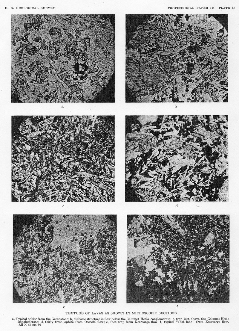
There may be differences of opinion as to the appropriateness of the names used in this classification, but to anyone who has examined drill cores from this series of rocks there can be no doubt as to the usefulness of the distinctions. The textural features that have been emphasized come out very strongly on the ground surface of drill cores, as can be seen by reference to Plate 56. Lane's classification has therefore been used in the maps and sections accompanying this report.
Ophite. - Ophitic texture is the roughly circular mottling of the rock produced by crystals of pyroxene that surround and inclose the feldspar crystals (pls. 5e, 57). The ophitic lavas are the "luster-mottled melaphyres" of the, earlier publications on. the district. The size of the pyroxene crystals varies with their distance from the contact of cooling and somewhat with the composition of the lava, Lane
23 has given an exhaustive discussion of this subject and its application, which need not be repeated here. Roughly he finds that the size of the pyroxenes increases 1 millimeter for each 8 to 10 feet of distance from the upper or lower contact of the flow. It is needless to say that this fact is of great value in studying the flows having ophitic texture. In some of the thick flows, like the Greenstone flow, the crystals are 2 inches and more in diameter, and their outlines are not readily traced in the ordinary sized drill core, but they are conspicuous on a weathered surface, where the centers stand up as knobs, and in freshly broken rock they can be seen by the flashing of cleavage faces.Where inclusions have been dragged into a flow the mottling around them is finer than elsewhere at a corresponding distance from the surfaces of the flow. This may account for some of the ophites of varying or banded mottling.
Porphyrites. -- The porphyrites are rocks that contain well-defined crystals, usually of feldspar, of an older generation than the same mineral in the groundmass.
Glomeroporphyrites. - In the glomeroporphyrites the feldspars show a considerable variation in size, though not so definite a difference in size and time of formation as is shown between the feldspar phenocrysts and the groundmass feldspars in the porphyrites. The larger feldspars are collected into bunches or clots.
Melaphyre. - Melaphyre is a term applied to rocks that show none of the distinctive textures indicated above. Many beds that show a distinctive texture near the center lose it near the margins, and many thin flows do not show a distinctive texture in any part. There are also some flows 100 feet or more in thickness that show no distinctive, to texture and are classed as melaphyre.
Dolerite. - The term dolerite is used to designate portions, in the lavas of certain types, in which the minerals, especially the feldspars, are unusually coarse and the rock has a pegmatitic texture. Rock of this type occurs in the thicker beds and is regarded as portions that crystallized late. It is allied to the pegmatite facies of some intrusive rocks. The term dolerite has been used by some petrographers in a different sense.
RELATION OF TEXTURE TO COMPOSITION
The ophitic texture is best developed in the more basic lavas, where it is conspicuous even in the thin flows and very near to the margin of the thick flows. In the more feldspathic lavas the ophitic texture may be conspicuous near the center of thick flows but absent from the thinner flows and near the margin of the thicker flows.
The porphyritic and glomeroporphyritic textures are characteristic of the more feldspathic beds or those approaching andesite, though phenocrysts are present in some ophitic flows, as the Kearsarge flow, in which they are especially abundant just below the amygdaloidal top.
The melaphyre texture, as already indicated, is found in the less basic beds. The feldspathic beds in the south end of the district show no definite texture and are of the melaphyre type.
DISTRIBUTION OF THE DIFFERENT ROCKS
Most parts of the section are characterized by the predominance of one or another of these textural types, which were produced by recurrences of different phases of the eruption of lava.
Below No. 6 conglomerate (see pl. 15) the flows are prevailingly ophites, commonly of the banded type. For a few hundred feet below and several hundred feet above No. 8 conglomerate, glomeroporphyrites and melaphyres predominate, especially from Portage Lake north to Keweenaw County. The series of thin beds above No. 8 conglomerate are typically glomeroporphyrites. Between the Kearsarge conglomerate and the "Mesnard" epidote the flows are typically ophites, and above the "Mesnard" glomeroporphyrites and melaphyres prevail. The flows above the Great conglomerate and below the Outer conglomerate - the Lake Shore trap - are melaphyres. Commonly there is a transition zone of varying width between the flows of different types, in which the rock is intermediate and more variable in composition.
In the south end of the district the "Chippewa" felsite, a siliceous rock of rhyolitic composition, forms a continuous belt in the upper part of the lava series and also crops out in the central area of the Porcupine Mountains. This rock is similar in composition and character to some of the felsite intrusives, and its presence in. the center of the Porcupine dome therefore naturally suggested, to Irving and those who have studied it since, the possibility that it is intrusive and that the dome is of laccolithic origin. That there are intrusive rocks in this area is known, but those who have studied the felsite have regarded it as an effusive which has been domed with the other rocks and have correlated it with the "Chippewa" felsite belt, to the south.
NOTES
10 For a discussion of the age and relations of the Keweenawan see Van Hise. C. R., and Leith, C. K., The geology of the Lake Superior region: U.S.. Geol. Survey Mon. 52, pp. 384, 389, 415, 416, 616, 626, 625, 1911: Lane, A. C., The Keweenawan series of Michigan. Michigan Geol. Survey Pub. 6 (Geol. ser. 4), ,}pp. 41, 629, 630, 941-942, 1909.
10a Since this report was prepared C. R. Stauffer (Age of the red clastic series of Minnesota: Geol Soc. America Bull., vol. 38, pp. 469-478, 1927) has reported the finding of Middle Cambrian fossils near the top of the red sediments below the St. Croixan series in Minnesota. These rocks have in the past been correlated, somewhat uncertainly, with the Keweenawan.
11 Lane, A. C., op. cit., p. 20.
12 Lane, A. C., Geological report on Isle Royale, Mich.: Michigan Geol. Survey, vol. 6 pt. 1, 1898.
13 Van Hise, C. R.., and Leith, C. K., op, cit., p. 417. Lane, A. C., The Keweenawan Series of Michigan: Michigan Geol. Survey Pub. 6, Geol. ser. 4, p, 32, 1909.
14 Marvine, A. R., Michigan Geol. Survey, vol. 1, pt. 2, 1873.
15 Lane, A. C., The Keweenawan series of Michigan: Michigan Geol. Survey Pub. 6; (Geol. ser. 4), p. 753, 1908.
16 Aldrich, H. R., Magnetic surveying on the copper-bearing rocks of Wisconsin: Econ. Geology, vol. 18 p. 569, 1923.
17 Idem, p. 571.
18 Hotchkiss, W. O., Lake Superior geosyncline Geol. Soc. America Bull., vol. 34 pp. 669 -678, 1923.
19 Van Hise, C. R.. and Leith, C. K., op cit., p. 414. Lane, A.C. Jour. Geology vol. 15, p. 690, 1907.
20 Lane, A. C. The Keweenaw series of Michigan: Michigan Geol. Survey Pub. 6 (Geol. ser. 4), pp. 409, 565, 1908.
21 Aldrich, H. R., Econ. Geology, vol. 18, p. 570, 1923.
22 Washington, H. S., Deccan traps and other plateau basalts: Geol. Soc. America Bull., vol. 33, pp. 774, 779, 789, 1932.
23 Lane, A. C., Michigan Geol. Survey Pub. 6 (Geol. ser. 4), vol. 1, p. 145, 1911.
Collector's Corner Previous section Table of Contents Next section