| Home | AmMin | GMR | RiMG | Collectors Corner | Directory | Short Courses | |
|
|
|||||||

|
VIRTUAL FIELD TRIP TO THE KEWEENAW PENINSULA, MICHIGAN - PLEISTOCENE GEOLOGIC HISTORY
|
The glaciers in the past two million years have had a significant effect on shaping the Keweenaw peninsula. They have gouged out Lake Superior, the interior lakes on the peninsula and control the topography of the peninsula. There are thin (50-100 feet) glacial deposits covering most of the area, except where more resistant rocks form hills and cliffs. Four major glaciations occurred during the last two million years. The majority of the landforms were developed during the retreat of the last Wisconsin stage glaciation. The maximum amount of ice over the peninsula was over 3000 m as the ice sheets reached into central Illinois and Ohio. As the ice sheets retreated, there were various glacial lakes filling the Lake Superior basin. Higher lake levels are evidenced by the formation of terraces ( basically stranded beaches). Isostatic rebound ( crustal uplift due to the unloading of the weight of the ice) causes the terraces to dip to the south. Most of the peninsula is covered by hummocky ground moraine. Glacial features include grooves and striations, moraines, eskers and kames.
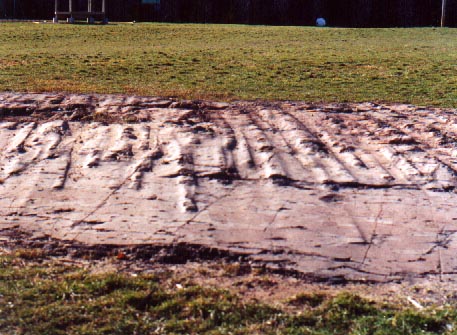
Glacial grooves (Stop 33 N47° 14.74' W88° 26.82') at Calumet behind the school. Spacing between grooves is 25 cm with a 3-5 cm amplitude. These grooves are caused by rocks at the bottom of the glacier being plowed though the bedrock. The finer grained material carried by the glacier causes the bedrock to become polished.
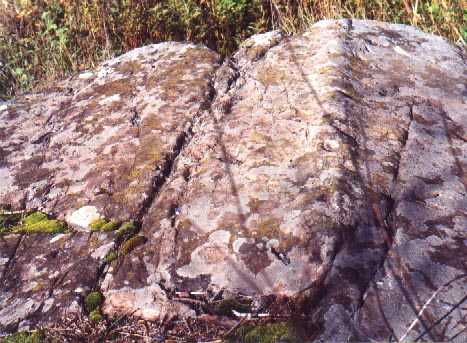
Glacial grooves on basalt (Stop 3) Hurontown. Small roches moutonnees are developed here ( smooth slope facing direction of ice movement with a plucked steep slope on the down side of ice movement).
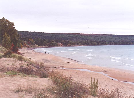
An atypical sand beach (Great Sand Bay - N47° 26.53' W88° 13.07'). Sand was produced from glacial Lake Superior's Nipissing Stage. Most of the beaches consist of weathered volcanic rocks or reworked volcanics found in the conglomerates ( some minor purple pebbles at curve in bay). Sand dunes are developed by the wind further onshore. On the eastern shore of the peninsula, white beaches were derived from the country rocks (Jacobsville sandstone).
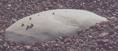
Glacial erratic. Stop C1 Horseshoe Harbor. This 50cm boulder was transported by the glaciers from Canada. The more pockmarked section near the center was a xenolith of a more granitic rock stoped into a slightly more felsic rock. |
 |
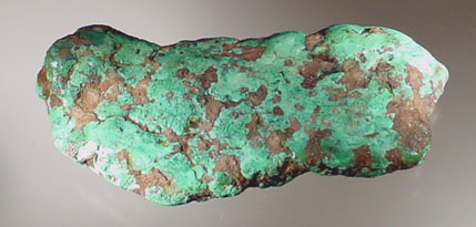 |
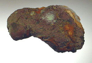
| The glaciers also transported native copper to the south. This 7 cm. long specimen was found in glacial till near Waupaca, Wisconsin, approximately 200 miles south of Houghton. Note the areas of alteration to malachite. The rock has also been slightly rounded during the transport in the glacier. Specimen consists almost completely of native copper with minor areas of iron oxides/hydroxides. | This 11 cm. specimen is from the Houghton area. It has been in contact with the ground water for a sufficient period of time to develop a thick coating of malachite. Specimens of float copper were valued by the native Americans since they could be worked with relative ease and did not require mining. Even though this specimen was not transported as far as the specimen to the left, there was more abrasion and rounding of the copper. |
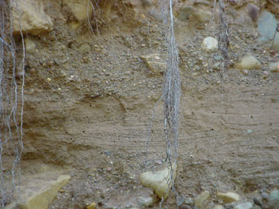 |
| Glacial sediments, Caledonia mine. These glacial crossbedded sands and conglomerates were formed by deposition in a small glacial lake that emptied when the ice melted. Field of view is one meter. |