USGS Professional Paper 144 pp 169-175
PART 3. DETAILED DESCRIPTION OF LODES AND FISSURES
In the following pages the ore deposits are described by lodes and fissures. A description by properties would in some cases cover deposits on several lodes and fissures, and a description by mines would in several cases cover but a part of a lode. The descriptions of lodes are arranged in order of stratigraphic position from higher to lower.
NONESUCH LODE
The Nonesuch lode is present throughout the Copper Range of Michigan, but prospecting and mining in it have been confined to the vicinity of the Porcupine Mountains, mainly around their east end. The White Pine mine is the only one that has made a notable production of copper from the Nonesuch lode. It was the only mine on the lode that was accessible at the time that this study was made, and therefore most of the statements regarding mineralization on the lode are based on observations made in that mine.
STRATIGRAPHIC OCCURRENCE
The Nonesuch lode is near the base of the Nonesuch shale, which lies between the Copper Harbor group and the Freda sandstone and is the highest formation known to be mineralized in the district. The Nonesuch formation is made up predominantly of red and black shales and red sandstone. Near its base is a persistent gray sandstone about 7 feet thick overlain by a thick black shale. Below the sandstone is about 4 to 6 feet of black shale followed by red sandstone and lenses of conglomerate. The gray sandstone underlying the thick black shale, the thin bed of shale below, and a few feet of sandstone below the shale are the most persistently mineralized strata in the formation, but where mineralization has been greatest it has extended to a maximum distance of 75 or 80 feet below the base of the black shale.
The black shale is a rather finely laminated, somewhat chloritic rock. Specimens of the shale from the White Pine mine, when heated in a closed tube, give off the tarry odor of hydrocarbons. The sandstone layers, which are predominantly red, range from medium-grained sandstone through grit to conglomerate, with pebbles several inches in diameter. The conglomerate consists mainly of pebbles of felsite and quartz porphyry and thus resembles the conglomerates of the principal copper district to the northeast. The sandstone of the beds it which the copper occurs is seen under the microscope to be made up of medium to coarse grained fragments, largely subangular. The constituents are quartz, feldspar, epidote, tourmaline, apatite, iron oxides, chlorite, micas, jasper, and fragments of felsite, trap, and volcanic glass in a matrix of finer grains of the same kinds, with calcite, silica, and iron oxides in considerable amount as cementing materials. Changes in the sandstone due to mineralization are mentioned on page 171.
STRUCTURE
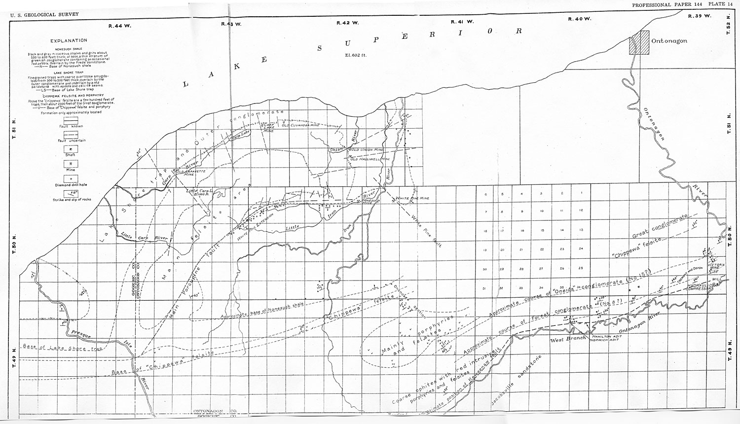
Structurally the Porcupine Mountain area is a domical uplift that constitutes a conspicuous irregularity on the south limb of the Lake Superior syncline. Felsite and coarser porphyry occupy the center of this uplift. Around and dipping away from them are the Eagle River group and younger formations, including the formation of particular economic interest, the Nonesuch. The uplift has not merely domed the beds upward but some of the beds have been broken across, so that although the felsite is in contact with the traps of the Eagle River group on the north and northwest sides of the mountains, it is brought against very steeply inclined younger rocks, including Nonesuch beds, on the southeast side.
Irving and later Wright and Lane explained the absence of the older rocks (like the Eagle River traps) on the southeast side of the felsite as due to a fault, called the "main Porcupine fault," along the margin of the felsite. Where the eastern end of this supposed fault is indicated on the original map of Wright and Lane, exploration between the White Pine and Nonesuch mines shows no fault to be present. If the felsite mass is an intrusive, this cutting out of certain beds along its border might be explained as a crosscutting intrusive contact.
The deformation in the Porcupine region may be a result of the injection of an igneous mass from below. The shape and nature of the uplift suggest that the intrusive body assumed the toadstool shape of the forms known as laccoliths. Over 40 years ago Irving recognized this structural similarity, but he concluded that "these mountains owe their existence in all probability to a fold," and thus he was left with the presumption that the felsite is a surface flow. Lane also concluded that both the narrow east-west belt of felsite south of the mountains and the larger body of felsite in the Porcupine- Mountains region are effusive.
Lane, however, mentions several small intrusive masses just, beyond the northwestern margin of the main felsite area (secs. 3 and 4, T. 50 N., R. 44 W.), also intrusive rocks, including felsites similar in appearance to that in the Porcupine Mountain mass, a few miles to the southeast; and these felsitic masses may be offshoots from a common source.
The structure of the region is probably due to the intrusion of an igneous mass of later age than any of the rocks in which deposits of copper and silver are found. The indications of intrusive force acting upward and outward are not confined to the general doming of the overlying rocks and to the cutting out of certain beds west of the Nonesuch mine. Inspection of Wright and Lane's geologic map of the Porcupine region (see pl. 14) shows the presence of numerous faults disposed radially across the felsite contact on both the north and south sides of the mountains, and also the pushing outward from the east end of the felsite mass of a fan-shaped block some 3 miles wide from north to south, at the horizon of the base of the Nonesuch formation, and a mile wide at the top of the Lake Shore trap, south of the old Halliwell mine As marked by the offset in the base of the Nonesuch shale, this block has been shoved eastward for nearly 2 miles.
The geologic details regarding this displaced block are known only along its southern edge, where the explorations of the White Pine mine have revealed certain features clearly. It seems evident that the outthrusting of the block was accomplished by a combination of faulting and of buckling or folding of the beds. Its south or southwest side is bounded by a nearly vertical fault, the White Pine fault, and as indicated on the map and shown by certain drilling explorations, its north side is likewise marked by a fault, which extends eastward from the old Halliwell mine. But on the south side, at least, these faults were developed only after the rocks had been folded so sharply that they broke across, and further dislocation was effected by faulting.
There is a suggestion from the map that farther north similar blocks between faults radially arranged with respect to the east end of the main felsite mass have similarly been shoved out away from the mountain, though to a somewhat shorter distance.
Branching from the reverse White Pine faults as shown in the White Pine mine are numerous minor faults that break the beds in the vicinity of the major faults. The details of these faults are given in the description of the White Pine mine (p. 172).
All the known features connected with this particular part of the region point to the production of the structural features by the intrusion of the igneous core of the Porcupine Mountains and the doming up and outward thrusting of the rocks that were invaded. This general setting helps to an understanding of the details of structure that have exerted a control on the ore. deposition in the White Pine mine.
MINERALIZATION
ORE MINERALS
The ore minerals are native copper, native silver, and chalcocite. The native metals occur chiefly as cementing material in the sandstone lodes and as disseminated grains or as flakes lying along jointing planes in the shales. Subordinately they are present in fissures and fault gouges. Chalcocite occurs most conspicuously in small fissure veins, with calcite gangue. It is also sparsely disseminated in the sandstones and in the shales.
FAVORABLE CONDITIONS
The conditions that have been effective in localizing the ore minerals are the confining effect of relatively impermeable shales, proximity to fractures that acted as channels for the introduction of ore-carrying solutions, and favorable mineralogic or textural conditions of certain beds in the sandstones.
Influence of shale beds. - The lodes are in the sandstone close underneath the thick capping of shale, which acted as a barrier to the rising solutions that deposited the ore. The two beds most widely mineralized are immediately below the shale, separated from each other by a few feet of mineralized shale. At the White Pine mine, where mineralization has been most intense near fissures, certain beds have been mineralized for 70 to 80 feet below the heavy overlying shale, but each of the lower beds has for its hanging wall or roof a bed of sandstone somewhat more shaly than normal, which seems to have acted as a barrier to the rising solutions.
Influence of fissures. - The deposits at the White Pine mine are closely connected with the White Pine fault and the associated branch faults, as is discussed in detail on page 173. Faults occur also in the vicinity of the Nonesuch and White Pine Extension mines, though there is no definite record of their relation to mineralization. Longyear,1 who was in charge of an exploration in T. 51 N., Rs. 41 and 42 W., north of the White Pine mine, says: "The drilling here has shown the principal mineralized areas to be in the immediate vicinity of the three northeast and south west faults." Lane 2 also some years ago pointed out the importance of prospecting along faults in the Porcupine Mountain district. Altogether the evidence seems to point very definitely to the association of mineralization with faults.
The ore-bearing solutions appear to have risen along the faults from a deep-seated source till they reached the heavy shale bed, in which the fault fissures were impermeable owing to the formation of gouge in these soft rocks. Below this impermeable bed the solutions spread out into the more permeable rocks and deposited the ore minerals.
Mineralogic and textural influences. - The third factor in controlling the distribution of the copper is the physical and mineralogic character of the beds impregnated. In so far as this factor may relate to differences between the particular beds mineralized and other near-by layers of the sandstone, it is believed to be of somewhat less importance than the two factors just discussed - namely, proximity to one of the larger cross faults and an impervious cap rock. Near one of these faults at the White Pine mine the mineralized layer is thicker than it is farther away. Within the lodes the copper is in many places confined to certain beds. Thus a lode 6 feet thick may have most of its copper in two or more layers that together make up not more than one-third of the total. In most hand specimens, and in thin sections as well, the copper is seen to follow certain bedding planes. This habit is undoubtedly due to some favorable textural or mineralogic features of the beds, but these have not been recognized except by the presence of copper associated with them.
The sandstones at the base of the Nonesuch shale, like most sandstones of the Keweenaw an series of the Lake Superior region, are predominantly red. The red color is due to the rather plentiful ferric oxide with which the felsitic grains are impregnated and also ferric oxide, which, together with calcite, forms the chief cementing material of the rocks.
The sandstone layers that carry copper have been bleached to a gray or greenish-gray color. Thin sections from the lode at the White Pine mine show that there is not much calcite remaining, but in its place as a cement is a pitchy black hydrocarbon, in an amount reaching a maximum of probably 2 per cent. The greenish tinge in this bleached rock is due to chlorite, which occurs largely as fringes about the sand grains and especially around the edges of the patches of hydrocarbon. The ferric oxide originally present in the unbleached rock has evidently been reduced to ferrous oxide and in part gone into combination as chlorite, but most of it appears to have been removed. This bleaching has occurred whether or not impregnation with copper has taken place just at that point. Many drill records show "gray sandstone" at the horizon of the lodes, but its copper content may be very low.
The impression gained from study of the sandstones in the White Pine mine is that the hydrocarbon, like the copper, has been introduced along the fissures and that its abundance has been determined by the same factors - namely, the presence of an impervious capping, proximity to a pronounced cross fault, and certain textural and mineralogic features of the beds.
The hydrocarbon, like the copper, occurs below the shale and shaly sandstone and is distributed through a greater thickness of beds and in greater amounts near the cross faults. It is more abundant in certain layers at these horizons, perhaps in those which were rich in replaceable calcite. The hydrocarbon occurs in the cross faults and fissures to an even greater proportionate extent than the copper; good-sized pieces of 10 to 20 pounds in weight made up largely of hydrocarbon have been obtained from such faults. The hydrocarbon is thought to have a greater horizontal distribution along the lodes than the copper, however, as it is found extending out along the beds farther than copper in commercial quantity.
The source of the hydrocarbon is not known with certainty, but inasmuch as the overlying black shale is bituminous, yielding a tarry distillate when heated in a glass tube, it seems probable that the hydrocarbon has been derived either from this shale or from some similar rock that may lie deeper in the series, by distillation under the heat and pressure attendant upon the intrusion and metamorphism of the region, or perhaps it was removed by the heated waters that carried the copper, although none of the shale seen in the mine appears to be leached or to have lost any of its black pigment.
The genetic relations of this carbonaceous substance and the copper are not entirely clear. Inasmuch as the same general conditions controlled the distribution of each, they are closely associated. The copper occurs in many places as a shell about the hydrocarbon, replacing the chlorite fringe. The period of deposition of hydrocarbon therefore was finished before that of the copper. Furthermore, the massive hydrocarbon of the fault zones is well impregnated with copper; whether this, means replacement of the hydrocarbon by copper or simultaneous deposition of the two is not clear.
These relations might be thought to suggest that the hydrocarbon was active as a precipitant of the copper. In all the mines of the main productive region to the northeast, however, copper has been precipitated in the lodes that are high in ferric iron, and the precipitation has been attended by bleaching of the rock occasioned by reduction and removal of the iron but without the slightest evidence that any hydrocarbon has been involved. This is as true of the conglomerate lodes (parts of which are made up of sandstone like the lodes at the White Pine mine) as it is of the amygdaloid lodes. Bleaching of the rock through reduction and removal of the iron is likewise characteristic of the White Pine lodes. It is evident that the copper of the White Pine district entered an environment that would have been favorable for copper precipitation had there been no hydrocarbon present. The facts that copper occurs close to bituminous shale only in the Porcupine region and that so far as known hydrocarbon is associated with copper only in that region, and everywhere close to the shale, lend weight to the view that the hydrocarbon has been derived locally from the shale and at best exerted but a subordinate and modifying influence on the deposition of the copper, if indeed it had any influence at all.
In summary it may be repeated that the textural and mineralogic factors in the localization of the copper are of minor importance. The following generalizations may be made regarding the color of the sandstone and the presence of hydrocarbon and of copper:
1. No copper was seen in red sandstone, although copper occurs in gray bands in red sandstone.
2. No gray sandstone was seen at the White Pine mine without some hydrocarbon.
3. Little if any hydrocarbon was noted in red sandstone.
4. Gray sandstone without copper was noted.
5. The sandstone of the lodes may have been in part rendered gray by the hydrocarbon before the copper had all been deposited.
6. Although there seems to be a close connection between the hydrocarbon and the copper, it may be purely fortuitous; in any case the indications are that the copper solutions entered what would have been a favorable environment for copper precipitation had there been no hydrocarbon present.
7. Here, as in the larger deposits farther northeast, the deposition of copper is believed to have been accomplished by the oxidizing effect of ferric oxide in the rocks upon the copper sulphide solutions. In the fractures themselves, where the contact of the solutions with the rock was less intimate, part of the copper was deposited as native metal and part as the sulphide chalcocite.
WHITE PINE MINE
Location and topography. - The White Pine mine (pl. 33) is in sees. 4, 5, 8, and 9, T. 50 N., R. 42 W., Ontonagon County, a few miles east of the Porcupine Mountains, and is the most southwesterly producer among the mines of the copper district.
In the immediate vicinity of the mine the country, which stands about 200 feet above Lake Superior, is flat and monotonous. The bedrock is buried by glacial drift as much as 160 feet in thickness. The northward-flowing streams have cut rather shallow valleys into the drift and in places have exposed bedrock. These exposures and the drill records show that the rock surface also is one of little relief.
Production. - The White Pine Copper Co. was organized in 1909. Its production and dividends to the end of 1923 were as follows:
Rock stamped ------------------------ tons 887,654
Refined copper produced:
Total ----------------------- pounds- 18,233,169
Per ton of rock ----------------- do------- 20. 54
Silver produced
------------------- ounces- 260,681
Dividends paid:
Total ----------------------------------- 533,438
Per pound of copper-------------- cent.---- 0. 18
Rocks - The following section is compiled from the notes of drill hole No. 162, 1,800 feet south. of No. 3 shaft, supplemented by the data obtained in the mine concerning the rocks below the Second lode. The members of particular economic importance are indicated by indention.
Section at White Pine mine
Feet
Red shale -------------------------------------------- 300+
Red sandstone and shale ----------------------------- 530
Black shale ------------------------------------------ 300
Brown and black shale
and gray sandstone ----------- 200
Black shale --------------------------------------- 70-110
Gray sandstone (First lode)
----------------------------- 7
Black shale (parting shale) ------------------------------ 6
Gray to red sandstone 3 (Second lode)
------------------ 7
Red sandstone ----------------------------------------- 13
Gray to red sandstone a (lower Second lode) ----------- 6
Red sandstone ----------------------------------------- 17
Felsite conglomerate ------------------------------------ 3
Red sandstone ---------------------------------------- 15
Gray to red sandstone 3 (Third lode) ------------------- 8
Red sandstone --------------------------------------- 600+
Structure. - The relation of the structure of the White Pine area to the general structural features of the region is shown on the map of the Porcupine Mountains and vicinity (pl. 14). In greater detail, the structure near the mine is shown in the small map of Plate 33, which shows the contour plan of the first lode, compiled from diamond-drill records and mine workings.
In the neighborhood of the White Pine mine the rocks have been dislocated along a southeast line so that those on the northeast side have been moved southeastward about 2 miles (as marked by the position of the first lode at the level of Lake Superior) and upward probably more than 1,500 feet. This diagonal upward displacement has been accomplished partly by a buckling fold, which accounts for the strong curvature of the lode as it approaches the fault, and partly by faulting, which produces perhaps half of the total horizontal displacement and likewise about half of the total vertical displacement. The White Pine fault is of reverse throw; it dips steeply northeast, and its northeast side, containing most of the mine workings, is the upthrown side.
As this dislocation forms the southwestern boundary of the outthrust block, it is evident that the block on the northeast side of the fault - that is, the block that contains the principal mine workings-moved, and that on the southwest was stationary, relative to the country rock in general. It is probable that the block that moved would suffer greater stresses than the one that remained at rest, and it seems likely that the region of the present mine workings (I, pl. 33) is a place of greater disturbance than the region on the opposite side of the fault (III). Faulting of the rocks appears favorable for the occurrence of ore in this locality, as is shown below.
The minor faults that are numerous in the developed portion of the mine are irregular in strike, dip, and throw, but certain generalizations concerning their behavior can be made. Two principal ones (N and K, pl. 33), from which many of the others are subordinate branches, are well exposed underground. The existence of another fault of apparently similar direction of strike and throw is suggested by the drill records in the neighborhood of S, some 1,500 feet east of No. 5 shaft. The known faults, like N and K, decrease in amount of throw as distance from the White Pine fault increases. The place at which the suggested dislocation S is revealed is distinctly farther from the supposed continuation of the White Pine fault than the farthest known extensions of N and K, yet the displacement at S is greater than the maximum at N and K. There is a possibility, therefore, that S is a larger fault than the others and that nearer to the White Pine fault along S there may exist either a single strong fault or a region of disturbance similar to that in the N-K block and of even greater intensity.
The known cross faults, with the exception of K and a few smaller ones, have their downthrown side to the southeast. As the fault K has its downthrown side to the northwest, the greater part of the block of ground between No. 3 and No. 4 shafts has been dropped with respect to the blocks on the northwest and southeast. The faults N and K have caused a greater displacement of the lodes than any of the others that were traceable for any considerable distance through the mine. Their displacement is variable, but in general they bring the First lode on one side well down toward the Third lode on the other side; this implies some 40 to 50 feet of vertical displacement. Most of the cross faults cause a displacement of less than 10 feet.
These cross faults as a rule are curved rather than straight, and many of them twist surprisingly. They are probably contemporaneous with the major dislocation represented by the folding and by the White Pine fault. The curvature is convex in dip as well as in strike toward the southeast until the faults finally become tangent to the White Pine fault. They branch, horsetail fashion, on the convex side as they swing away from the White Pine fault, and they decrease in amount of throw outward from it. All these facts suggest that these minor cross faults are due to drag along the major White Pine fault in or near a semi-plastic material such as the thick overlying shale.
Mineralization. - The general features of the mineralization of the Nonesuch lode are described on pages 169-171, but the special relation of the faults branching from the White Pine fault may be pointed out. The evidence of the premineral age of the cross faults lies in the facts that the lodes are thickest and richest in the immediate vicinity of the larger cross faults, and that the cross faults themselves are well mineralized, even the smallest joints and fissures in the sandstone and adjacent shale carrying copper.
The richest ground in the mine is in and immediately adjacent to the block between the principal cross faults, N and K. Here the lodes are both thickest and richest.
The records of the diamond drilling from the surface give the copper percentages for the several mineralized beds. Multiplying each of these percentages by the number of feet of rock which it represents and adding together these products gives a percentage-foot figure for each hole that represents what may be termed the "intensity of mineralization" of the ground penetrated. To obtain these figures, only the footages of ground that assayed 0.5 per cent or more of copper were considered. For example, the intensity of mineralization of a given hole is computed thus:
| Material | Feet | Copper (per cent) | Computation |
| Black shale | 80 | trace | |
| Gray sandstone | 5 | 1.6 | 5X1.6=8.0 |
| Black shale | 6 | 0.45 | |
| Gray sandstone | 7 | 1.35 | 7X1.35= 9.45 |
| 17.45 |
Plate 33 shows the position of each drill hole together with the intensity of mineralization as thus obtained for it, also contours drawn at 25-unit intervals over the entire area drilled. It is apparent that the block between faults N and K and the immediate vicinity is by far the richest ground drilled, copper contents and thickness of lodes both being considered.
The evidence of the drill records was confirmed by sampling in the workings of the mine at different intervals, chiefly east of the fault K. Over 50 samples were taken, assays for which were furnished by Mr. C. H. Benedict. The places for sampling the several lodes were selected as nearly along the same vertical line as the exposures in the workings allowed. Thus the same method of multiplying percentage of copper by thickness of lode and adding the products gives figures which represent "intensity of mineralization" at different places. These figures likewise show that mineralization is most intense near the fault K, grading outward from it toward No. 5 shaft. Minor deviations from the general rule are probably due to the enriching effect of subordinate fractures near points where the assay samples were taken.
Plate 33 shows that shafts Nos. 3 and 4 are in the heart of the only noteworthy ore body penetrated by the drilling. The holes to the northeast and northwest along the outcrop of the lodes indicate that the mineralization. is slight there as compared with that in the present workings.
Other evidence indicating that faults N and K were channels for the mineralizing solutions is afforded by a series of small but very rich ore bodies, including all the rich silver bodies seen, which cling very close to these faults. They are in the nature of thickenings of the normal lodes, and mineralization of two lodes that are not mineralized generally through the mine - namely, the Lower Second lode and the Third lode. The mineralization of the Third lode, so far as now known, is confined to the highly mineralized part of the area, centering about N and K.
Plate 33 shows that in places outside of the present mine workings where there are breaks in the structural contours, indicating cross faulting, there are increases in the mineralization. Such places are found in the NE. 1/4 sec. 6 and the NE. 1/4 sec. 9 (fault S).
To summarize: In the White Pine mine the copper was probably brought in by solutions ascending along the White Pine fault. As these solutions leaked out into the somewhat permeable sandstone, they continued to ascend in the sandstone until they were diverted slantingly upward by the shale barriers. But the movement of solutions was also facilitated by the cross faults, and especially by the stronger ones. By this combination of conditions the favorable portions of the rock were afforded a sufficient volume of solution to become commercial lodes, whereas farther away from the faults the richness falls below the economic limit. Copper or chalcocite was also de posited in the faults and fractures themselves. This relation between faults and the best mineralization is in accord with the experience of those who have worked elsewhere in the Porcupine Mountain district.
Extensions of ore bodies. - Development of the lodes at the White Pine mine has been carried from the outcrop down to the White Pine fault. The lode has been located on the downthrown side of the fault, but development of it has been very slight, and principally at No. 2 shaft. As indicated in the discussion of structure there are some reasons for supposing that the downthrown block may be less broken by branch faults than the upthrown block and therefore less favorable to mineralization. If the solutions were rising along the White Pine fault it also seems probable that the beds on the upthrown side were more favorably situated to receive them.
Diamond drilling shows that the beds associated with the branch fault east of the White Pine mine workings are mineralized at some distance from the main fault, and it seems possible that this mineralization may be more intense nearer the main fault.
WHITE PINE EXTENSION MINE
The following statements regarding the White Pine Extension mine are largely compiled from the records of the company. The mine is in T. 50 N., R. 44 W., about 8 miles west of the White Pine mine. The workings are in the Nonesuch formation south of the Porcupine Mountain uplift. The property has been developed by diamond drilling across sees. 7, 12, 13, and 14, with a total. of 45 holes ranging in depth from 80 to 1,400 feet. A shaft has been sunk to a depth on the incline of 438 feet, and drifts have been opened on the No. 2 shale on the second and fourth levels for a maximum distance of 3,380 feet.
The rocks belong to the Nonesuch formation, which, as shown in the drill cores from the Freda sandstone downward, includes the following beds:
Feet
Brown shale and sandstone --------------------- 280-380
Upper grit
---------------------------------------- 40- 50
Bedded gray shale group
----------------------- 125-150
Lower grit
------------------------------------------- 10±
No. 1 shale
------------------------------------------ 15±
No. 1 sandstone -------------------------------------- 6±
No. 2 shale
------------------------------------------- 4½
No. 2 sandstone.
Red sandstone.
The beds dip away from the Porcupine Mountain uplift at an angle of 83° in the mine workings. They appear to be regular in the main, though there is minor faulting across the lodes.
Mineralization has occurred mainly in No. 1 shale, No. 2 shale, and a bed in the sandstone about 9 feet below No. 2 shale, known as No. 3 sandstone. At 33 feet from No. 2 shale a crosscut on the fourth level encountered "quartz-banded shale" with disseminated sulphide which assayed 20 pounds of copper to the ton for a thickness of 3 feet. The copper occurs in the shale mainly as thin sheets and flakes in the bed partings and joints.
Drifts have been opened on No. 2 shale with crosscuts at 100-foot intervals to No. 1 shale and at 200-foot intervals to No. 3 sandstone. When operations ceased in May, 1918, the following work had been accomplished
Feet
Shaft, incline depth -------------------------------------- 438
First level, incline depth ----------------------------------- 55
Second level, incline depth ------------------------------- 220
Third level, incline depth --------------------------------- 320
Fourth level, incline depth -------------------------------- 420
Drifts:
First level, 14 feet north, 11 feet south ------------------ 25
Second level, 1,542
feet north, 1,838 feet south ---- 3, 380
Fourth level, 1,138 feet north, 1,080
feet south------ 2,218
Crosscuts
------------------------------------------- 1,322
7,383
No. 2 shale for a width of 4.8 feet, including some barren shale that breaks with the ore, has an average copper content of 21 pounds to the ton. North of the shaft there is some relatively poor ground averaging about 13 pounds to the ton. If this is eliminated, the south ends of the drifts average between 23 and 24 pounds to the ton.
A total of 23 samples of No. 1 shale assaying from 6 to 20 pounds to the ton gave an average of 12 pounds for a thickness of 5.7 feet.
A total of 10 observations on No. 3 sandstone on the second level showed a width of 1.6 to 3 feet and a copper content of 0 to 28 pounds. On the fourth level the sandstone showed no mineralization and in some crosscuts could not be identified.
When the mine was closed water was being pumped at the rate of 92 gallons a minute.
NONESUCH MINE
The Nonesuch mine, about 3 miles west of the White Pine, was productive intermittently from 1868 to 1885, and its recorded production is 389,556 pounds of copper. The mine is developed by four shafts.4 No. 3, the deepest, went to the fifth level, a depth of 460 feet. The occurrence of the ore, apparently, is similar to that of the neighboring White Pine mine.
ONONDAGA EXPLORATION
The Nonesuch formation was examined by diamond drilling by the Onondaga Copper Co. in Tps. 49 and 50 N., Rs. 42 and 43 W., on the south side of the structural basin south of the Porcupine Mountains. The formation is similar to that on the north side of the basin, but the copper content as revealed by the drilling did not warrant development.
OTHER PROPERTIES
North and northeast of the White Pine mine pits have been sunk in days past on bunches of copper or silver ore in the sandstone, apparently associated with faults. Some of these faults may be of a magnitude corresponding to that of the White Pine fault. (See pl. 14.)
The rocks at the Nonesuch horizon were examined by diamond drilling in T. 51 N., Rs. 41 and 42 W.
Some copper was found, and the best ground was reported to be near the faults, but it was not further developed.
NOTES
1 Longyear, C. S., Michigan Geol. Survey Pub. 24, ser. 20, p. 20, 1916.
2 Lane, A. C., Unexplored parts of the Copper Range of Keweenaw Point: Lake Superior Mining Inst. Bull., vol. 17, p. 133, 1912.
3 Gray where mineralized: elsewhere red.
4 Comm. Mineral Statistics Ann. Rept. for 1883, pp. 153-154, 1884.
Collector's Corner Previous section Table of Contents Next section