| Home | AmMin | GMR | RiMG | Collectors Corner | Directory | Short Courses | |
|
|
|||||||

|
Volume 7, pages 83-86, 1922 NOTES ON SAND CALCITE FROM SOUTH DAKOTA HAROLD R. WANLESS, Princeton University It was the writer's privilege last summer to visit the Rattlesnake Butte locality in South Dakota where great quantities of sand calcite crystals may be obtained, and, as this locality would doubtless be very interesting to mineralogists who might be in the vicinity, some notes on it are presented here. Rattlesnake Butte, or the Devil's Hill, is situated on the Pine Ridge Indian Reservation approximately 23 miles (37 km.) straight south of the town of Interior, Jackson County, S. D. This is on the Black Hills line of the Chicago, Milwaukee, and St. Paul Railway, about 80 miles east of Rapid City; Interior is also on the George Washington Highway. To reach the Rattlesnake Butte locality from Interior, one goes about one mile west on the Washington Highway, then south on a reservation road, crossing White River about two miles from town, then in general following the main travel, avoiding the first two right forks, and keeping to the right after they are passed for about 15 miles, then going through a gate where there are three forks, taking the middle branch. About a mile further one takes the right fork. This is near the top of a hill overlooking the valley of Bear in the Lodge Creek, and the Snake Butte Hills can be seen from here as a low line of hills with irregular rough tops about 6 miles south. Continuing straight south about four miles, one comes to an east-west fence around a half section, and the main road turns east along it.. When the fence is reached, one leaves the main road and follows a trail west along the fence to the end of the fence, then angles southwest over a hill for about l 1/2 miles, then leaving the road, turns left across an undulating grassy hill and the Snake Buttes, are about 1/4 mile distant. It is possible to drive right to the base of the buttes with a car. Further directions and conveyance can be procured from Mr. Campbell of the real estate firm of White and Campbell at Interior, who is familiar with the locality.
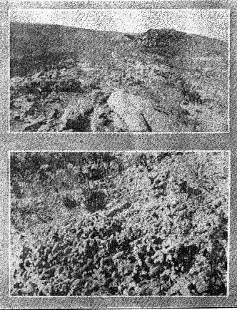
FIG. 1 (above): Sandstone capped ridge of Rattlesnake Butte. FIG 2 (below): Mass of sand calcite crystals from Rattlesnake Butte, S. D. The ridges are capped by a bed of coarse sandstone about three to four feet thick, and especially at the southern end of the line of hills great masses of perfect scalenohedrons of sand calcite are found, also single crystals and radiating rosette-structure masses, also massive pipes in which the identity of the crystals is lost. Analyses by Professor A. H. Phillips and the writer have found the per cent of calcite in the crystals to be 36.95-37 .00%. This seems to be a constant proportion. Mud and silt are present to 0.2% and the sand studied mineralogically yielded quartz, orthoclase, microcline, albite, muscovite, biotite, hornblende, augite, green, black and colorless prisms of tourmaline, zircon, garnet, staurolite, magnetite, and an opaque polished mineral, perhaps cassiterite, but in too small grains to be tested chemically. Besides this, fragments of volcanic glass and two varieties of mica schist were found. Most of the grains are well rounded and many have a ground glass surface, indicating rounding by wind action. The hornblende and augite grains are generally ellipsoidal, or prisms with rounded edges, and the magnetite, zircon, and quartz are generally nearly spherical. The garnets show some crystal faces and the tourmalines are good prisms, not rounded. Certain of the minerals present indicate derivation from preCambrian pegmatites (tourmaline) and schists (garnet, staurolite, and schist fragments) of the Black Hills. The presence of wind rounded volcanic ash is significant of the volcanic activity of the Cordilleran district of the early Tertiary. The age of the sand calcite crystals is Lower Miocene in stratigraphic position, though they may have been formed at a later period by the action of ground water. They were very likely formed by spring deposition at normal temperatures, but under some pressure of overlying rock. Their sand is evidently derived from coarse wind-blown sand of a dune deposit. Sand dunes are now not rare in this district and have probably been locally present throughout the Tertiary. The absence of mud and silt and the perfect rounding of the grains with wind-etched surfaces point clearly to dune origin. The method of analysis used to determine the minerals of the sands was as follows: (1) Treatment of a weighed sample with dilute HCl to dissolve out the calcite; the residue was weighed and per cent of calcite determined. (2) Sample treated by decantation to remove mud and silt and again weighed. (3) Sand residue treated with Thoulet's solution (sp. gr. 2.95) and the heavy minerals were thus concentrated. (4) Magnetic treatment of the heavy residue separated out the magnetite. (5) The light and heavy concentrates were studied with the binocular and petrographic microscopes, and the mineral species were determined by measuring their refractive indices by mean's of a series of liquids of known refraction.
|